Canroma geodata
Canroma (Western Visayas) is a populated place; located in Philippines in Asia/Manila (GMT+8) time zone. With population of 2,170 people, there are 3951 cities with bigger population in this country. Compared to other cities in Philippines, 64.6% of cities are located further ↑North; 51.2% of cities are located further ←West and 65.1% of cities have higher elevation than Canroma. Note1
Administrative division(s):
- Level 1: Western Visayas
- Level 2: Province of Negros Occidental
- Level 3: Pontevedra


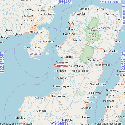
Canroma GPS coordinates[2]
10° 21' 38.16" North, 122° 52' 44.4" East
| Map corner | latitude | longitude |
|---|---|---|
| Upper-left | 11.05148°, | 122.17588° |
| Center: | 10.3606°, | 122.879° |
| Lower-right: | 9.66819°, | 123.58213° |
| Map W x H: | 153.8×153.8 km | = 95.6×95.6mi |
| max Lat: | 20.78733° ⇑64.6% North |
| Canroma: | 10.3606° |
| min Lat: | ⇓35.4% South 4.65442° |
| min Long | Canroma | max Long |
| 117.04868° | 122.879° | 126.58417° |
| W 51.2%⇐ | ⇒48.8% E |
Elevation
Elevation of Canroma is 14 m = 46 ft, and this is 73.9 m = 242 ft below average elevation for this country.
| Max E: |
2262 m = 7421 ft | 65.1% |
| Avg. | 87.9 m = 288 ft | |
| Canroma | 14 m = 46 ft | |
Min E: |
-2 m = -7 ft | 34.9% |
See also: Philippines elevation on elevation.city.
Geographical zone
Canroma is located in North Torrid zone (between Equator and Tropic of Cancer). Distance of Equator is 1152 km =715.8 mi to South.| Distance of | km | miles | from Canroma |
|---|---|---|---|
| North Pole | 8855.1 | 5502.3 | to North |
| Arctic Circle | 6249.2 | 3883.1 | to North |
| Tropic Cancer | 1453.9 | 903.4 | to North |
| Equator | 1152 | 715.8 | to South |


Nearby cities:
15 places around Canroma: (largest is in red/bold)
• Alijis
11.9 km =7.4 mi,  336°
336°
• Antipolo
9.4 km =5.8 mi,  92°
92°
• Bagumbayan
10.7 km =6.6 mi,  333°
333°
• Baliwagan
4.3 km =2.7 mi,  18°
18°
• Carmen Grande
4.5 km =2.8 mi,  63°
63°
• Himaya
11.3 km =7 mi, 333°
• Hinigaran
10.5 km =6.5 mi,  197°
197°
• La Carlota
8.4 km =5.2 mi,  33°
33°
• Miranda
6.2 km =3.9 mi,  181°
181°
• Pacol
12.1 km =7.5 mi, 325°
• Pontevedra
2 km =1.2 mi,  322°
322°
• Sagasa
12.1 km =7.5 mi,  7°
7°
• San Enrique
6.9 km =4.3 mi, 333°
• San Juan
3.3 km =2.1 mi, 332°
• Sibucao
6.4 km =4 mi, 7°
Sources, notices
• [Note1] Compared only with cities in Philippines existing in our database
• [Src1] Map data: © OpenStreetMap contributors (CC-BY-SA)
• [Src2] Other city data from geonames.org with taken over terms of usage.
• [Src3] Geographical zone / Annual Mean Temperature by Robert A. Rohde @ Wikipedia
