Caluya geodata
Caluya (Western Visayas) is a seat of a third-order administrative division; located in Philippines in Asia/Manila (GMT+8) time zone. In our database, there are 4166 cities with bigger population. Compared to other cities in Philippines, 51.5% of cities are located further ↓South; 66% of cities are located further →East and 89.7% of cities have higher elevation than Caluya. Note1


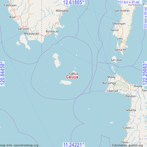
Caluya GPS coordinates[2]
11° 55' 51.6" North, 121° 32' 51.72" East
| Map corner | latitude | longitude |
|---|---|---|
| Upper-left | 12.61805°, | 120.84458° |
| Center: | 11.931°, | 121.5477° |
| Lower-right: | 11.24221°, | 122.25083° |
| Map W x H: | 153×153 km | = 95.1×95.1mi |
| max Lat: | 20.78733° ⇑48.5% North |
| Caluya: | 11.931° |
| min Lat: | ⇓51.5% South 4.65442° |
| min Long | Caluya | max Long |
| 117.04868° | 121.5477° | 126.58417° |
| W 34%⇐ | ⇒66% E |
Elevation
Elevation of Caluya is 7 m = 23 ft, and this is 80.9 m = 265 ft below average elevation for this country.
| Max E: |
2262 m = 7421 ft | 89.7% |
| Avg. | 87.9 m = 288 ft | |
| Caluya | 7 m = 23 ft | |
Min E: |
-2 m = -7 ft | 10.3% |
See also: Philippines elevation on elevation.city.
Geographical zone
Caluya is located in North Torrid zone (between Equator and Tropic of Cancer). Distance of this Northern Tropic circle is 1279.3 km =794.9 mi to North.| Distance of | km | miles | from Caluya |
|---|---|---|---|
| North Pole | 8680.5 | 5393.8 | to North |
| Arctic Circle | 6074.6 | 3774.6 | to North |
| Tropic Cancer | 1279.3 | 794.9 | to North |
| Equator | 1326.6 | 824.3 | to South |


Nearby cities:
15 places around Caluya: (largest is in red/bold)
• Agcogon
47 km =29.2 mi,  72°
72°
• Alibug
48 km =29.8 mi,  313°
313°
• Balabag
40.6 km =25.2 mi,  83°
83°
• Buruanga
38.3 km =23.8 mi,  104°
104°
• Caticlan
44.8 km =27.8 mi,  89°
89°
• Jarigue
13.8 km =8.6 mi,  237°
237°
• Lanas
42.4 km =26.3 mi, 71°
• Libertad
44.2 km =27.5 mi,  113°
113°
• Malabonot
40.7 km =25.3 mi, 84°
• Malay
39.5 km =24.5 mi, 94°
• Manoc-Manoc
43 km =26.7 mi, 88°
• Semirara
22.4 km =13.9 mi, 313°
• Tinogboc
17 km =10.6 mi,  299°
299°
• Union
42.4 km =26.3 mi,  116°
116°
• Yapak
42 km =26.1 mi, 87°
Sources, notices
• [Note1] Compared only with cities in Philippines existing in our database
• [Src1] Map data: © OpenStreetMap contributors (CC-BY-SA)
• [Src2] Other city data from geonames.org with taken over terms of usage.
• [Src3] Geographical zone / Annual Mean Temperature by Robert A. Rohde @ Wikipedia
