Kinatakutan geodata
Kinatakutan (Calabarzon) is a populated place; located in Philippines in Asia/Manila (GMT+8) time zone. With population of 2,703 people, there are 2941 cities with bigger population in this country. Compared to other cities in Philippines, 68.3% of cities are located further ↓South; 55.4% of cities are located further →East and 52.3% of cities have lower elevation than Kinatakutan. Note1


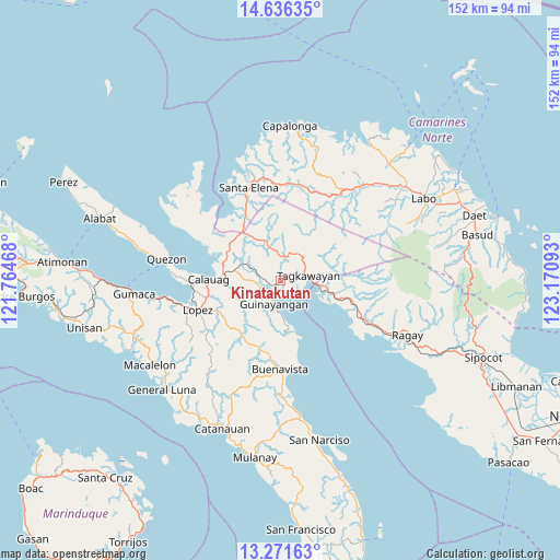
Kinatakutan GPS coordinates[2]
13° 57' 18" North, 122° 28' 4.08" East
| Map corner | latitude | longitude |
|---|---|---|
| Upper-left | 14.63635°, | 121.76468° |
| Center: | 13.955°, | 122.4678° |
| Lower-right: | 13.27163°, | 123.17093° |
| Map W x H: | 151.7×151.7 km | = 94.3×94.3mi |
| max Lat: | 20.78733° ⇑31.7% North |
| Kinatakutan: | 13.955° |
| min Lat: | ⇓68.3% South 4.65442° |
| min Long | Kinatakutan | max Long |
| 117.04868° | 122.4678° | 126.58417° |
| W 44.6%⇐ | ⇒55.4% E |
Elevation
Elevation of Kinatakutan is 25 m = 82 ft, and this is 62.9 m = 206 ft below average elevation for this country.
| Max E: |
2262 m = 7421 ft | 47.7% |
| Avg. | 87.9 m = 288 ft | |
| Kinatakutan | 25 m = 82 ft | |
Min E: |
-2 m = -7 ft | 52.3% |
See also: Philippines elevation on elevation.city.
Geographical zone
Kinatakutan is located in North Torrid zone (between Equator and Tropic of Cancer). Distance of this Northern Tropic circle is 1054.3 km =655.1 mi to North.| Distance of | km | miles | from Kinatakutan |
|---|---|---|---|
| North Pole | 8455.4 | 5253.9 | to North |
| Arctic Circle | 5849.5 | 3634.7 | to North |
| Tropic Cancer | 1054.3 | 655.1 | to North |
| Equator | 1551.7 | 964.2 | to South |


Nearby cities:
15 places around Kinatakutan: (largest is in red/bold)
• Calauag
19.4 km =12.1 mi,  270°
270°
• Capuluan
16.3 km =10.1 mi,  161°
161°
• Catabangan
22.6 km =14 mi,  112°
112°
• Del Gallego
14.2 km =8.8 mi,  104°
104°
• Guinayangan, Fourth District of Quezon
6.5 km =4 mi,  199°
199°
• Hondagua
24.4 km =15.2 mi, 267°
• Lopez
23.7 km =14.7 mi,  250°
250°
• Malatap
26.2 km =16.3 mi,  10°
10°
• Mapulot
11.7 km =7.3 mi,  41°
41°
• Rizal
19.9 km =12.4 mi, 268°
• Rosario
23.3 km =14.5 mi,  244°
244°
• Santa Elena
25.6 km =15.9 mi,  338°
338°
• Sinuknipan
19.7 km =12.2 mi, 111°
• Tagkawayan Sabang
7.8 km =4.8 mi,  59°
59°
• Tigbinan
25.7 km =16 mi,  0°
0°
Sources, notices
• [Note1] Compared only with cities in Philippines existing in our database
• [Src1] Map data: © OpenStreetMap contributors (CC-BY-SA)
• [Src2] Other city data from geonames.org with taken over terms of usage.
• [Src3] Geographical zone / Annual Mean Temperature by Robert A. Rohde @ Wikipedia
