Santa Cecilia geodata
Santa Cecilia (Calabarzon) is a populated place; located in Philippines in Asia/Manila (GMT+8) time zone. With population of 4,230 people, there are 1614 cities with bigger population in this country. Compared to other cities in Philippines, 70.4% of cities are located further ↓South; 58% of cities are located further →East and 80.7% of cities have higher elevation than Santa Cecilia. Note1


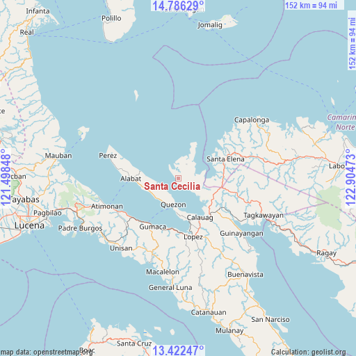
Santa Cecilia GPS coordinates[2]
14° 6' 19.44" North, 122° 12' 5.76" East
| Map corner | latitude | longitude |
|---|---|---|
| Upper-left | 14.78629°, | 121.49848° |
| Center: | 14.1054°, | 122.2016° |
| Lower-right: | 13.42247°, | 122.90473° |
| Map W x H: | 151.6×151.6 km | = 94.2×94.2mi |
| max Lat: | 20.78733° ⇑29.6% North |
| Santa Cecilia: | 14.1054° |
| min Lat: | ⇓70.4% South 4.65442° |
| min Long | Santa Cecilia | max Long |
| 117.04868° | 122.2016° | 126.58417° |
| W 42%⇐ | ⇒58% E |
Elevation
Elevation of Santa Cecilia is 9 m = 30 ft, and this is 78.9 m = 259 ft below average elevation for this country.
| Max E: |
2262 m = 7421 ft | 80.7% |
| Avg. | 87.9 m = 288 ft | |
| Santa Cecilia | 9 m = 30 ft | |
Min E: |
-2 m = -7 ft | 19.3% |
See also: Philippines elevation on elevation.city.
Geographical zone
Santa Cecilia is located in North Torrid zone (between Equator and Tropic of Cancer). Distance of this Northern Tropic circle is 1037.5 km =644.7 mi to North.| Distance of | km | miles | from Santa Cecilia |
|---|---|---|---|
| North Pole | 8438.7 | 5243.6 | to North |
| Arctic Circle | 5832.8 | 3624.3 | to North |
| Tropic Cancer | 1037.5 | 644.7 | to North |
| Equator | 1568.4 | 974.6 | to South |


Nearby cities:
15 places around Santa Cecilia: (largest is in red/bold)
• Alabat
20.4 km =12.7 mi,  268°
268°
• Basiad
15.7 km =9.8 mi,  68°
68°
• Calauag
18.9 km =11.7 mi,  150°
150°
• Camohaguin
22.2 km =13.8 mi,  189°
189°
• Gumaca
23.2 km =14.4 mi,  208°
208°
• Hondagua
18.3 km =11.4 mi,  166°
166°
• Lopez
25.4 km =15.8 mi, 165°
• Mainit Norte
24.3 km =15.1 mi,  285°
285°
• Panikihan
23.2 km =14.4 mi,  199°
199°
• Plaridel
25.7 km =16 mi,  229°
229°
• Progreso
25 km =15.5 mi, 208°
• Quezon
11.3 km =7 mi, 189°
• Rizal
19.4 km =12.1 mi, 152°
• San Vicente
23.2 km =14.4 mi,  179°
179°
• Santa Elena
20.8 km =12.9 mi, 69°
Sources, notices
• [Note1] Compared only with cities in Philippines existing in our database
• [Src1] Map data: © OpenStreetMap contributors (CC-BY-SA)
• [Src2] Other city data from geonames.org with taken over terms of usage.
• [Src3] Geographical zone / Annual Mean Temperature by Robert A. Rohde @ Wikipedia
