Calatagan geodata
Calatagan (Calabarzon) is a seat of a third-order administrative division; located in Philippines in Asia/Manila (GMT+8) time zone. With population of 16,110 people, there are 425 cities with bigger population in this country. Compared to other cities in Philippines, 66% of cities are located further ↓South; 87.1% of cities are located further →East and 67.4% of cities have higher elevation than Calatagan. Note1


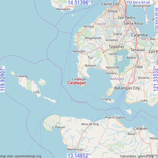
Calatagan GPS coordinates[2]
13° 49' 56.064" North, 120° 37' 55.884" East
| Map corner | latitude | longitude |
|---|---|---|
| Upper-left | 14.51396°, | 119.92907° |
| Center: | 13.83224°, | 120.63219° |
| Lower-right: | 13.14852°, | 121.33532° |
| Map W x H: | 151.8×151.8 km | = 94.3×94.3mi |
| max Lat: | 20.78733° ⇑34% North |
| Calatagan: | 13.83224° |
| min Lat: | ⇓66% South 4.65442° |
| min Long | Calatagan | max Long |
| 117.04868° | 120.63219° | 126.58417° |
| W 12.9%⇐ | ⇒87.1% E |
Elevation
Elevation of Calatagan is 13 m = 43 ft, and this is 74.9 m = 246 ft below average elevation for this country.
| Max E: |
2262 m = 7421 ft | 67.4% |
| Avg. | 87.9 m = 288 ft | |
| Calatagan | 13 m = 43 ft | |
Min E: |
-2 m = -7 ft | 32.6% |
See also: Philippines elevation on elevation.city.
Geographical zone
Calatagan is located in North Torrid zone (between Equator and Tropic of Cancer). Distance of this Northern Tropic circle is 1067.9 km =663.6 mi to North.| Distance of | km | miles | from Calatagan |
|---|---|---|---|
| North Pole | 8469.1 | 5262.5 | to North |
| Arctic Circle | 5863.2 | 3643.2 | to North |
| Tropic Cancer | 1067.9 | 663.6 | to North |
| Equator | 1538 | 955.7 | to South |


Nearby cities:
15 places around Calatagan: (largest is in red/bold)
• Balayan
15.9 km =9.9 mi,  42°
42°
• Balibago
10.4 km =6.5 mi,  356°
356°
• Balitoc
3.4 km =2.1 mi,  6°
6°
• Biga
8.2 km =5.1 mi, 12°
• Binubusan
15.3 km =9.5 mi,  1°
1°
• Bungahan
12.7 km =7.9 mi, 14°
• Calaca
22.5 km =14 mi,  60°
60°
• Calantas
21.9 km =13.6 mi, 44°
• Gulod
4.8 km =3 mi, 1°
• Hukay
7.8 km =4.8 mi,  79°
79°
• Lian
22.5 km =14 mi, 4°
• Lucsuhin
5.6 km =3.5 mi, 10°
• Prinza
18.4 km =11.4 mi, 7°
• Putol
20.5 km =12.7 mi,  30°
30°
• Talisay
9.2 km =5.7 mi,  354°
354°
Sources, notices
• [Note1] Compared only with cities in Philippines existing in our database
• [Src1] Map data: © OpenStreetMap contributors (CC-BY-SA)
• [Src2] Other city data from geonames.org with taken over terms of usage.
• [Src3] Geographical zone / Annual Mean Temperature by Robert A. Rohde @ Wikipedia
