Calaca geodata
Calaca (Calabarzon) is a seat of a third-order administrative division; located in Philippines in Asia/Manila (GMT+8) time zone. With population of 37,443 people, there are 229 cities with bigger population in this country. Compared to other cities in Philippines, 68% of cities are located further ↓South; 81.9% of cities are located further →East and 51.1% of cities have lower elevation than Calaca. Note1


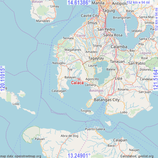
Calaca GPS coordinates[2]
13° 55' 56.784" North, 120° 48' 47.772" East
| Map corner | latitude | longitude |
|---|---|---|
| Upper-left | 14.61386°, | 120.11015° |
| Center: | 13.93244°, | 120.81327° |
| Lower-right: | 13.24901°, | 121.5164° |
| Map W x H: | 151.8×151.8 km | = 94.3×94.3mi |
| max Lat: | 20.78733° ⇑32% North |
| Calaca: | 13.93244° |
| min Lat: | ⇓68% South 4.65442° |
| min Long | Calaca | max Long |
| 117.04868° | 120.81327° | 126.58417° |
| W 18.1%⇐ | ⇒81.9% E |
Elevation
Elevation of Calaca is 24 m = 79 ft, and this is 63.9 m = 210 ft below average elevation for this country.
| Max E: |
2262 m = 7421 ft | 48.9% |
| Avg. | 87.9 m = 288 ft | |
| Calaca | 24 m = 79 ft | |
Min E: |
-2 m = -7 ft | 51.1% |
See also: Philippines elevation on elevation.city.
Geographical zone
Calaca is located in North Torrid zone (between Equator and Tropic of Cancer). Distance of this Northern Tropic circle is 1056.8 km =656.7 mi to North.| Distance of | km | miles | from Calaca |
|---|---|---|---|
| North Pole | 8457.9 | 5255.5 | to North |
| Arctic Circle | 5852 | 3636.3 | to North |
| Tropic Cancer | 1056.8 | 656.7 | to North |
| Equator | 1549.1 | 962.6 | to South |


Nearby cities:
15 places around Calaca: (largest is in red/bold)
• Agoncillo
12.9 km =8 mi,  88°
88°
• Balayan
8.8 km =5.5 mi,  273°
273°
• Bolboc
11.6 km =7.2 mi,  327°
327°
• Calantas
6.1 km =3.8 mi,  316°
316°
• Dayapan
11.1 km =6.9 mi, 87°
• Lemery
12.3 km =7.6 mi,  117°
117°
• Mataywanac
14.2 km =8.8 mi, 320°
• Matingain
7.5 km =4.7 mi,  106°
106°
• Payapa
11.2 km =7 mi,  49°
49°
• Putol
11.4 km =7.1 mi,  305°
305°
• San Luis
14.1 km =8.8 mi,  127°
127°
• Sinisian
3.8 km =2.4 mi, 119°
• Subic
13.8 km =8.6 mi,  82°
82°
• Taal
13.2 km =8.2 mi, 116°
• Tuy
13.1 km =8.1 mi, 316°
Sources, notices
• [Note1] Compared only with cities in Philippines existing in our database
• [Src1] Map data: © OpenStreetMap contributors (CC-BY-SA)
• [Src2] Other city data from geonames.org with taken over terms of usage.
• [Src3] Geographical zone / Annual Mean Temperature by Robert A. Rohde @ Wikipedia
