Panabingan geodata
Panabingan (Central Luzon) is a populated place; located in Philippines in Asia/Manila (GMT+8) time zone. With population of 2,683 people, there are 2974 cities with bigger population in this country. Compared to other cities in Philippines, 80.6% of cities are located further ↓South; 83.3% of cities are located further →East and 53.1% of cities have higher elevation than Panabingan. Note1
Administrative division(s):
- Level 1: Central Luzon
- Level 2: Province of Nueva Ecija
- Level 3: San Antonio


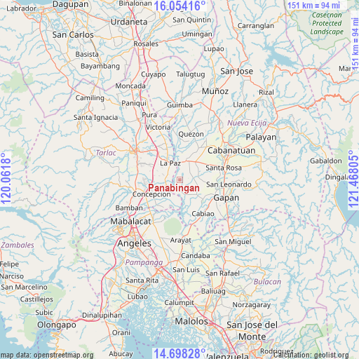
Panabingan GPS coordinates[2]
15° 22' 38.352" North, 120° 45' 53.712" East
| Map corner | latitude | longitude |
|---|---|---|
| Upper-left | 16.05416°, | 120.0618° |
| Center: | 15.37732°, | 120.76492° |
| Lower-right: | 14.69828°, | 121.46805° |
| Map W x H: | 150.8×150.8 km | = 93.7×93.7mi |
| max Lat: | 20.78733° ⇑19.4% North |
| Panabingan: | 15.37732° |
| min Lat: | ⇓80.6% South 4.65442° |
| min Long | Panabingan | max Long |
| 117.04868° | 120.76492° | 126.58417° |
| W 16.7%⇐ | ⇒83.3% E |
Elevation
Elevation of Panabingan is 21 m = 69 ft, and this is 66.9 m = 219 ft below average elevation for this country.
| Max E: |
2262 m = 7421 ft | 53.1% |
| Avg. | 87.9 m = 288 ft | |
| Panabingan | 21 m = 69 ft | |
Min E: |
-2 m = -7 ft | 46.9% |
See also: Philippines elevation on elevation.city.
Geographical zone
Panabingan is located in North Torrid zone (between Equator and Tropic of Cancer). Distance of this Northern Tropic circle is 896.1 km =556.8 mi to North.| Distance of | km | miles | from Panabingan |
|---|---|---|---|
| North Pole | 8297.3 | 5155.7 | to North |
| Arctic Circle | 5691.4 | 3536.5 | to North |
| Tropic Cancer | 896.1 | 556.8 | to North |
| Equator | 1709.8 | 1062.4 | to South |


Nearby cities:
15 places around Panabingan: (largest is in red/bold)
• Batitang
4.8 km =3 mi,  57°
57°
• Cafe
7.7 km =4.8 mi,  234°
234°
• Cama Juan
1.7 km =1.1 mi,  12°
12°
• Comillas
7.3 km =4.5 mi,  288°
288°
• Concepcion
8.4 km =5.2 mi,  27°
27°
• Dumarais
10.1 km =6.3 mi,  309°
309°
• La Paz
8.1 km =5 mi,  331°
331°
• Macarse
5.4 km =3.4 mi, 11°
• Marawa
9 km =5.6 mi, 60°
• Pando
8.8 km =5.5 mi,  282°
282°
• Papaya
9.9 km =6.2 mi,  129°
129°
• San Francisco
8.4 km =5.2 mi,  106°
106°
• San Isidro
8.4 km =5.2 mi, 329°
• Santa Barbara
3.4 km =2.1 mi,  75°
75°
• Santa Monica
5.3 km =3.3 mi,  245°
245°
Sources, notices
• [Note1] Compared only with cities in Philippines existing in our database
• [Src1] Map data: © OpenStreetMap contributors (CC-BY-SA)
• [Src2] Other city data from geonames.org with taken over terms of usage.
• [Src3] Geographical zone / Annual Mean Temperature by Robert A. Rohde @ Wikipedia
