Cabulay geodata
Cabulay (Cagayan Valley) is a populated place; located in Philippines in Asia/Manila (GMT+8) time zone. With population of 2,829 people, there are 2742 cities with bigger population in this country. Compared to other cities in Philippines, 92% of cities are located further ↓South; 66.6% of cities are located further →East and 82% of cities have lower elevation than Cabulay. Note1


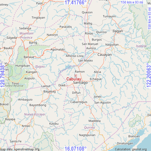
Cabulay GPS coordinates[2]
16° 44' 44.016" North, 121° 29' 51" East
| Map corner | latitude | longitude |
|---|---|---|
| Upper-left | 17.41766°, | 120.79438° |
| Center: | 16.74556°, | 121.4975° |
| Lower-right: | 16.07108°, | 122.20063° |
| Map W x H: | 149.7×149.7 km | = 93×93mi |
| max Lat: | 20.78733° ⇑8% North |
| Cabulay: | 16.74556° |
| min Lat: | ⇓92% South 4.65442° |
| min Long | Cabulay | max Long |
| 117.04868° | 121.4975° | 126.58417° |
| W 33.4%⇐ | ⇒66.6% E |
Elevation
Elevation of Cabulay is 106 m = 348 ft, and this is 18.1 m = 59 ft above average elevation for this country.
| Max E: |
2262 m = 7421 ft | 18% |
| Cabulay | 106 m 348 ft | |
| Avg. | 87.9 m = 288 ft | |
Min E: |
-2 m = -7 ft | 82% |
See also: Philippines elevation on elevation.city.
Geographical zone
Cabulay is located in North Torrid zone (between Equator and Tropic of Cancer). Distance of this Northern Tropic circle is 744 km =462.3 mi to North.| Distance of | km | miles | from Cabulay |
|---|---|---|---|
| North Pole | 8145.1 | 5061.1 | to North |
| Arctic Circle | 5539.2 | 3441.9 | to North |
| Tropic Cancer | 744 | 462.3 | to North |
| Equator | 1861.9 | 1156.9 | to South |


Nearby cities:
15 places around Cabulay: (largest is in red/bold)
• Batal
12.8 km =8 mi,  120°
120°
• Cordon
8.6 km =5.3 mi,  203°
203°
• Diadi
14.9 km =9.3 mi,  261°
261°
• Diffun
17.3 km =10.7 mi,  177°
177°
• Echague
19.6 km =12.2 mi,  103°
103°
• Potia
11.7 km =7.3 mi,  352°
352°
• Ramon
5.9 km =3.7 mi,  42°
42°
• Ramos West
13.4 km =8.3 mi,  112°
112°
• Rizal
6.8 km =4.2 mi, 115°
• Salinungan Proper
18.5 km =11.5 mi, 42°
• San Isidro
12.8 km =8 mi, 96°
• San Mateo
17.9 km =11.1 mi,  32°
32°
• Santiago
8.4 km =5.2 mi,  139°
139°
• Sinamar
18.7 km =11.6 mi,  23°
23°
• Soyung
18.6 km =11.6 mi, 105°
Sources, notices
• [Note1] Compared only with cities in Philippines existing in our database
• [Src1] Map data: © OpenStreetMap contributors (CC-BY-SA)
• [Src2] Other city data from geonames.org with taken over terms of usage.
• [Src3] Geographical zone / Annual Mean Temperature by Robert A. Rohde @ Wikipedia
