Diadi geodata
Diadi (Cagayan Valley) is a seat of a third-order administrative division; located in Philippines in Asia/Manila (GMT+8) time zone. With population of 15,567 people, there are 434 cities with bigger population in this country. Compared to other cities in Philippines, 92% of cities are located further ↓South; 69.2% of cities are located further →East and 91.6% of cities have lower elevation than Diadi. Note1
Administrative division(s):
- Level 1: Cagayan Valley
- Level 2: Province of Nueva Vizcaya
- Level 3: Diadi


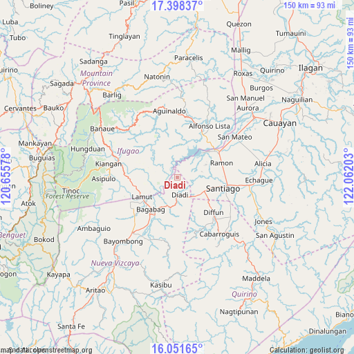
Diadi GPS coordinates[2]
16° 43' 34.32" North, 121° 21' 32.04" East
| Map corner | latitude | longitude |
|---|---|---|
| Upper-left | 17.39837°, | 120.65578° |
| Center: | 16.7262°, | 121.3589° |
| Lower-right: | 16.05165°, | 122.06203° |
| Map W x H: | 149.7×149.7 km | = 93×93mi |
| max Lat: | 20.78733° ⇑8% North |
| Diadi: | 16.7262° |
| min Lat: | ⇓92% South 4.65442° |
| min Long | Diadi | max Long |
| 117.04868° | 121.3589° | 126.58417° |
| W 30.8%⇐ | ⇒69.2% E |
Elevation
Elevation of Diadi is 276 m = 906 ft, and this is 188.1 m = 617 ft above average elevation for this country.
| Max E: |
2262 m = 7421 ft | 8.4% |
| Diadi | 276 m 906 ft | |
| Avg. | 87.9 m = 288 ft | |
Min E: |
-2 m = -7 ft | 91.6% |
See also: Philippines elevation on elevation.city.
Geographical zone
Diadi is located in North Torrid zone (between Equator and Tropic of Cancer). Distance of this Northern Tropic circle is 746.1 km =463.6 mi to North.| Distance of | km | miles | from Diadi |
|---|---|---|---|
| North Pole | 8147.3 | 5062.5 | to North |
| Arctic Circle | 5541.4 | 3443.3 | to North |
| Tropic Cancer | 746.1 | 463.6 | to North |
| Equator | 1859.8 | 1155.6 | to South |


Nearby cities:
15 places around Diadi: (largest is in red/bold)
• Bagabag
17.3 km =10.7 mi,  220°
220°
• Batal
26.1 km =16.2 mi,  99°
99°
• Bintawan
24.7 km =15.3 mi,  227°
227°
• Cabulay
14.9 km =9.3 mi,  81°
81°
• Cordon
12.8 km =8 mi,  116°
116°
• Diffun
21.8 km =13.5 mi,  134°
134°
• Ibung
22.5 km =14 mi, 234°
• Lagawe
26.8 km =16.7 mi,  287°
287°
• Lamut
16.7 km =10.4 mi,  239°
239°
• Potia
19.1 km =11.9 mi,  43°
43°
• Ramon
19.8 km =12.3 mi,  71°
71°
• Rizal
20.9 km =13 mi,  92°
92°
• Santiago
20.7 km =12.9 mi, 101°
• Tuao
18.7 km =11.6 mi, 215°
• Villa Verde
23.1 km =14.4 mi, 232°
Sources, notices
• [Note1] Compared only with cities in Philippines existing in our database
• [Src1] Map data: © OpenStreetMap contributors (CC-BY-SA)
• [Src2] Other city data from geonames.org with taken over terms of usage.
• [Src3] Geographical zone / Annual Mean Temperature by Robert A. Rohde @ Wikipedia
