Buyo geodata
Buyo (Bicol) is a populated place; located in Philippines in Asia/Manila (GMT+8) time zone. With population of 3,579 people, there are 1998 cities with bigger population in this country. Compared to other cities in Philippines, 58.2% of cities are located further ↓South; 69% of cities are located further ←West and 97.1% of cities have higher elevation than Buyo. Note1


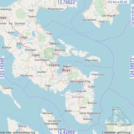
Buyo GPS coordinates[2]
13° 6' 51.84" North, 123° 51' 59.76" East
| Map corner | latitude | longitude |
|---|---|---|
| Upper-left | 13.79822°, | 123.16348° |
| Center: | 13.1144°, | 123.8666° |
| Lower-right: | 12.42868°, | 124.56973° |
| Map W x H: | 152.3×152.3 km | = 94.6×94.6mi |
| max Lat: | 20.78733° ⇑41.8% North |
| Buyo: | 13.1144° |
| min Lat: | ⇓58.2% South 4.65442° |
| min Long | Buyo | max Long |
| 117.04868° | 123.8666° | 126.58417° |
| W 69%⇐ | ⇒31% E |
Elevation
Elevation of Buyo is 4 m = 13 ft, and this is 83.9 m = 275 ft below average elevation for this country.
| Max E: |
2262 m = 7421 ft | 97.1% |
| Avg. | 87.9 m = 288 ft | |
| Buyo | 4 m = 13 ft | |
Min E: |
-2 m = -7 ft | 2.9% |
See also: Philippines elevation on elevation.city.
Geographical zone
Buyo is located in North Torrid zone (between Equator and Tropic of Cancer). Distance of this Northern Tropic circle is 1147.7 km =713.1 mi to North.| Distance of | km | miles | from Buyo |
|---|---|---|---|
| North Pole | 8548.9 | 5312 | to North |
| Arctic Circle | 5943 | 3692.8 | to North |
| Tropic Cancer | 1147.7 | 713.1 | to North |
| Equator | 1458.2 | 906.1 | to South |


Nearby cities:
15 places around Buyo: (largest is in red/bold)
• Bangkirohan
14.5 km =9 mi,  243°
243°
• Bariw
14.6 km =9.1 mi,  278°
278°
• Bigaa
15.2 km =9.4 mi,  308°
308°
• Legaspi
14 km =8.7 mi, 282°
• Manito
1.1 km =0.7 mi,  16°
16°
• Maslog
10.4 km =6.5 mi,  263°
263°
• Osiao
12.7 km =7.9 mi,  101°
101°
• Pawa
3.4 km =2.1 mi,  51°
51°
• Pili
14.9 km =9.3 mi,  181°
181°
• Sagpon
15 km =9.3 mi,  285°
285°
• San Francisco
12.5 km =7.8 mi,  226°
226°
• San Isidro
15.6 km =9.7 mi, 183°
• San Roque
13 km =8.1 mi, 290°
• San Vicente
15.9 km =9.9 mi,  197°
197°
• Santo Niño
11.1 km =6.9 mi, 95°
Sources, notices
• [Note1] Compared only with cities in Philippines existing in our database
• [Src1] Map data: © OpenStreetMap contributors (CC-BY-SA)
• [Src2] Other city data from geonames.org with taken over terms of usage.
• [Src3] Geographical zone / Annual Mean Temperature by Robert A. Rohde @ Wikipedia
