Pawa geodata
Pawa (Bicol) is a populated place; located in Philippines in Asia/Manila (GMT+8) time zone. With population of 2,123 people, there are 4039 cities with bigger population in this country. Compared to other cities in Philippines, 58.3% of cities are located further ↓South; 69.2% of cities are located further ←West and 71.2% of cities have lower elevation than Pawa. Note1


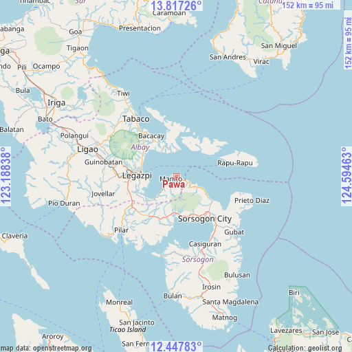
Pawa GPS coordinates[2]
13° 8' 0.6" North, 123° 53' 29.4" East
| Map corner | latitude | longitude |
|---|---|---|
| Upper-left | 13.81726°, | 123.18838° |
| Center: | 13.1335°, | 123.8915° |
| Lower-right: | 12.44783°, | 124.59463° |
| Map W x H: | 152.3×152.3 km | = 94.6×94.6mi |
| max Lat: | 20.78733° ⇑41.7% North |
| Pawa: | 13.1335° |
| min Lat: | ⇓58.3% South 4.65442° |
| min Long | Pawa | max Long |
| 117.04868° | 123.8915° | 126.58417° |
| W 69.2%⇐ | ⇒30.8% E |
Elevation
Elevation of Pawa is 55 m = 180 ft, and this is 32.9 m = 108 ft below average elevation for this country.
| Max E: |
2262 m = 7421 ft | 28.8% |
| Avg. | 87.9 m = 288 ft | |
| Pawa | 55 m = 180 ft | |
Min E: |
-2 m = -7 ft | 71.2% |
See also: Philippines elevation on elevation.city.
Geographical zone
Pawa is located in North Torrid zone (between Equator and Tropic of Cancer). Distance of this Northern Tropic circle is 1145.6 km =711.8 mi to North.| Distance of | km | miles | from Pawa |
|---|---|---|---|
| North Pole | 8546.8 | 5310.7 | to North |
| Arctic Circle | 5940.9 | 3691.5 | to North |
| Tropic Cancer | 1145.6 | 711.8 | to North |
| Equator | 1460.3 | 907.4 | to South |


Nearby cities:
15 places around Pawa: (largest is in red/bold)
• Bariw
17.1 km =10.6 mi,  269°
269°
• Basud
17.3 km =10.7 mi,  158°
158°
• Bigaa
16.3 km =10.1 mi,  296°
296°
• Buyo
3.4 km =2.1 mi,  231°
231°
• Legaspi
16.3 km =10.1 mi, 273°
• Libog
16.7 km =10.4 mi,  312°
312°
• Manito
2.6 km =1.6 mi,  245°
245°
• Maslog
13.4 km =8.3 mi,  256°
256°
• Osiao
10.8 km =6.7 mi,  115°
115°
• Padang
16.7 km =10.4 mi, 305°
• Sagpon
17.2 km =10.7 mi,  276°
276°
• San Francisco
15.9 km =9.9 mi, 227°
• San Roque
15.1 km =9.4 mi, 279°
• Santo Domingo
16.8 km =10.4 mi, 312°
• Santo Niño
8.9 km =5.5 mi,  111°
111°
Sources, notices
• [Note1] Compared only with cities in Philippines existing in our database
• [Src1] Map data: © OpenStreetMap contributors (CC-BY-SA)
• [Src2] Other city data from geonames.org with taken over terms of usage.
• [Src3] Geographical zone / Annual Mean Temperature by Robert A. Rohde @ Wikipedia
