Santo Niño geodata
Santo Niño (Bicol) is a populated place; located in Philippines in Asia/Manila (GMT+8) time zone. With population of 2,040 people, there are 4138 cities with bigger population in this country. Compared to other cities in Philippines, 58.1% of cities are located further ↓South; 70.4% of cities are located further ←West and 72% of cities have lower elevation than Santo Niño. Note1


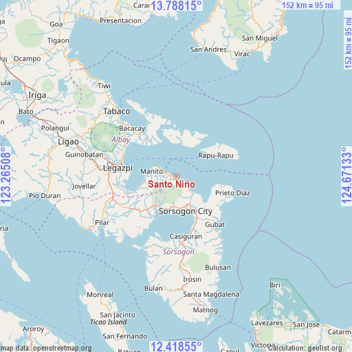
Santo Niño GPS coordinates[2]
13° 6' 15.48" North, 123° 58' 5.52" East
| Map corner | latitude | longitude |
|---|---|---|
| Upper-left | 13.78815°, | 123.26508° |
| Center: | 13.1043°, | 123.9682° |
| Lower-right: | 12.41855°, | 124.67133° |
| Map W x H: | 152.3×152.3 km | = 94.6×94.6mi |
| max Lat: | 20.78733° ⇑41.9% North |
| Santo Niño: | 13.1043° |
| min Lat: | ⇓58.1% South 4.65442° |
| min Long | Santo Niño | max Long |
| 117.04868° | 123.9682° | 126.58417° |
| W 70.4%⇐ | ⇒29.6% E |
Elevation
Elevation of Santo Niño is 57 m = 187 ft, and this is 30.9 m = 101 ft below average elevation for this country.
| Max E: |
2262 m = 7421 ft | 28% |
| Avg. | 87.9 m = 288 ft | |
| Santo Niño | 57 m = 187 ft | |
Min E: |
-2 m = -7 ft | 72% |
See also: Philippines elevation on elevation.city.
Geographical zone
Santo Niño is located in North Torrid zone (between Equator and Tropic of Cancer). Distance of this Northern Tropic circle is 1148.9 km =713.9 mi to North.| Distance of | km | miles | from Santo Niño |
|---|---|---|---|
| North Pole | 8550 | 5312.7 | to North |
| Arctic Circle | 5944.1 | 3693.5 | to North |
| Tropic Cancer | 1148.9 | 713.9 | to North |
| Equator | 1457.1 | 905.4 | to South |


Nearby cities:
15 places around Santo Niño: (largest is in red/bold)
• Bacon
10.8 km =6.7 mi,  133°
133°
• Balete
11.7 km =7.3 mi,  143°
143°
• Basud
13 km =8.1 mi,  188°
188°
• Buhatan
16.7 km =10.4 mi,  148°
148°
• Buyo
11.1 km =6.9 mi,  275°
275°
• Capuy
14 km =8.7 mi,  195°
195°
• Gabao
13.5 km =8.4 mi,  157°
157°
• Manito
10.9 km =6.8 mi, 281°
• Osiao
2 km =1.2 mi, 135°
• Pawa
8.9 km =5.5 mi,  291°
291°
• Pili
17.8 km =11.1 mi,  219°
219°
• Rizal
15.3 km =9.5 mi, 202°
• San Isidro
18.8 km =11.7 mi, 219°
• Sorsogon
14.8 km =9.2 mi,  169°
169°
• Sugod
17.8 km =11.1 mi, 136°
Sources, notices
• [Note1] Compared only with cities in Philippines existing in our database
• [Src1] Map data: © OpenStreetMap contributors (CC-BY-SA)
• [Src2] Other city data from geonames.org with taken over terms of usage.
• [Src3] Geographical zone / Annual Mean Temperature by Robert A. Rohde @ Wikipedia
