Manito geodata
Manito (Bicol) is a seat of a third-order administrative division; located in Philippines in Asia/Manila (GMT+8) time zone. With population of 3,008 people, there are 2520 cities with bigger population in this country. Compared to other cities in Philippines, 58.2% of cities are located further ↓South; 69.1% of cities are located further ←West and 55.6% of cities have lower elevation than Manito. Note1


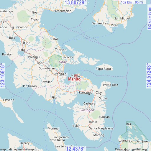
Manito GPS coordinates[2]
13° 7' 24.6" North, 123° 52' 9.48" East
| Map corner | latitude | longitude |
|---|---|---|
| Upper-left | 13.80729°, | 123.16618° |
| Center: | 13.1235°, | 123.8693° |
| Lower-right: | 12.4378°, | 124.57243° |
| Map W x H: | 152.3×152.3 km | = 94.6×94.6mi |
| max Lat: | 20.78733° ⇑41.8% North |
| Manito: | 13.1235° |
| min Lat: | ⇓58.2% South 4.65442° |
| min Long | Manito | max Long |
| 117.04868° | 123.8693° | 126.58417° |
| W 69.1%⇐ | ⇒30.9% E |
Elevation
Elevation of Manito is 28 m = 92 ft, and this is 59.9 m = 197 ft below average elevation for this country.
| Max E: |
2262 m = 7421 ft | 44.4% |
| Avg. | 87.9 m = 288 ft | |
| Manito | 28 m = 92 ft | |
Min E: |
-2 m = -7 ft | 55.6% |
See also: Philippines elevation on elevation.city.
Geographical zone
Manito is located in North Torrid zone (between Equator and Tropic of Cancer). Distance of this Northern Tropic circle is 1146.7 km =712.5 mi to North.| Distance of | km | miles | from Manito |
|---|---|---|---|
| North Pole | 8547.9 | 5311.4 | to North |
| Arctic Circle | 5942 | 3692.2 | to North |
| Tropic Cancer | 1146.7 | 712.5 | to North |
| Equator | 1459.2 | 906.7 | to South |


Nearby cities:
15 places around Manito: (largest is in red/bold)
• Bangkirohan
15.3 km =9.5 mi,  240°
240°
• Bariw
14.8 km =9.2 mi,  274°
274°
• Bigaa
14.8 km =9.2 mi,  304°
304°
• Buyo
1.1 km =0.7 mi,  196°
196°
• Legaspi
14.1 km =8.8 mi,  278°
278°
• Maslog
10.8 km =6.7 mi,  258°
258°
• Osiao
12.6 km =7.8 mi,  106°
106°
• Padang
15.5 km =9.6 mi,  313°
313°
• Pawa
2.6 km =1.6 mi,  65°
65°
• Pili
15.9 km =9.9 mi,  182°
182°
• Sagpon
15 km =9.3 mi, 281°
• San Francisco
13.4 km =8.3 mi,  224°
224°
• San Roque
12.9 km =8 mi,  285°
285°
• Santo Domingo
15.9 km =9.9 mi,  321°
321°
• Santo Niño
10.9 km =6.8 mi,  101°
101°
Sources, notices
• [Note1] Compared only with cities in Philippines existing in our database
• [Src1] Map data: © OpenStreetMap contributors (CC-BY-SA)
• [Src2] Other city data from geonames.org with taken over terms of usage.
• [Src3] Geographical zone / Annual Mean Temperature by Robert A. Rohde @ Wikipedia
