Anticala geodata
Anticala (Caraga) is a populated place; located in Philippines in Asia/Manila (GMT+8) time zone. With population of 3,246 people, there are 2260 cities with bigger population in this country. Compared to other cities in Philippines, 75.8% of cities are located further ↑North; 95.1% of cities are located further ←West and 75.5% of cities have lower elevation than Anticala. Note1
Administrative division(s):
- Level 1: Caraga
- Level 2: Province of Agusan del Norte
- Level 3: Butuan City


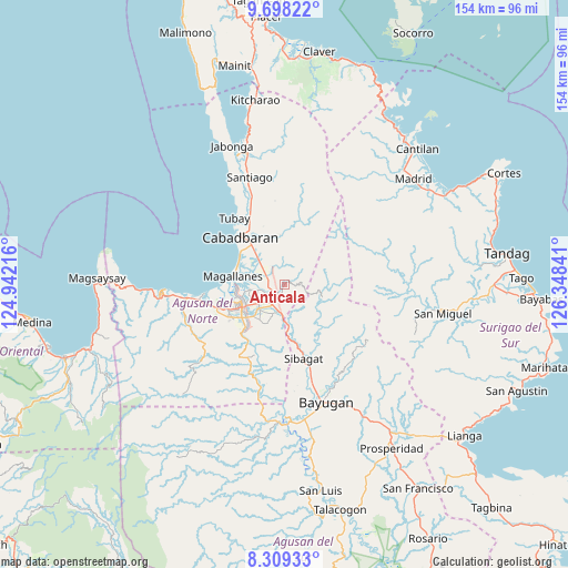
Anticala GPS coordinates[2]
9° 0' 15.984" North, 125° 38' 43.008" East
| Map corner | latitude | longitude |
|---|---|---|
| Upper-left | 9.69822°, | 124.94216° |
| Center: | 9.00444°, | 125.64528° |
| Lower-right: | 8.30933°, | 126.34841° |
| Map W x H: | 154.4×154.4 km | = 95.9×95.9mi |
| max Lat: | 20.78733° ⇑75.8% North |
| Anticala: | 9.00444° |
| min Lat: | ⇓24.2% South 4.65442° |
| min Long | Anticala | max Long |
| 117.04868° | 125.64528° | 126.58417° |
| W 95.1%⇐ | ⇒4.9% E |
Elevation
Elevation of Anticala is 70 m = 230 ft, and this is 17.9 m = 59 ft below average elevation for this country.
| Max E: |
2262 m = 7421 ft | 24.5% |
| Avg. | 87.9 m = 288 ft | |
| Anticala | 70 m = 230 ft | |
Min E: |
-2 m = -7 ft | 75.5% |
See also: Philippines elevation on elevation.city.
Geographical zone
Anticala is located in North Torrid zone (between Equator and Tropic of Cancer). Distance of Equator is 1001.2 km =622.1 mi to South.| Distance of | km | miles | from Anticala |
|---|---|---|---|
| North Pole | 9005.9 | 5596 | to North |
| Arctic Circle | 6400 | 3976.8 | to North |
| Tropic Cancer | 1604.7 | 997.1 | to North |
| Equator | 1001.2 | 622.1 | to South |


Nearby cities:
15 places around Anticala: (largest is in red/bold)
• Agay
8.4 km =5.2 mi,  310°
310°
• Balangbalang
6.3 km =3.9 mi,  337°
337°
• Basag
9.2 km =5.7 mi,  196°
196°
• Butuan
12.7 km =7.9 mi,  241°
241°
• Calamba
12.4 km =7.7 mi,  333°
333°
• Caloc-an
13.5 km =8.4 mi,  290°
290°
• Comagascas
17.7 km =11 mi, 328°
• Del Pilar
17.7 km =11 mi, 337°
• La Union
15 km =9.3 mi, 306°
• Libertad
17.1 km =10.6 mi,  246°
246°
• Lombocan
15.3 km =9.5 mi,  271°
271°
• Los Angeles
4.2 km =2.6 mi,  282°
282°
• Magallanes
14.2 km =8.8 mi, 277°
• Sanghan
12 km =7.5 mi,  318°
318°
• Taligaman
11.2 km =7 mi,  174°
174°
Sources, notices
• [Note1] Compared only with cities in Philippines existing in our database
• [Src1] Map data: © OpenStreetMap contributors (CC-BY-SA)
• [Src2] Other city data from geonames.org with taken over terms of usage.
• [Src3] Geographical zone / Annual Mean Temperature by Robert A. Rohde @ Wikipedia
