Bucay geodata
Bucay (Cordillera) is a seat of a third-order administrative division; located in Philippines in Asia/Manila (GMT+8) time zone. In our database, there are 4166 cities with bigger population. Compared to other cities in Philippines, 96.3% of cities are located further ↓South; 84.4% of cities are located further →East and 80.7% of cities have lower elevation than Bucay. Note1


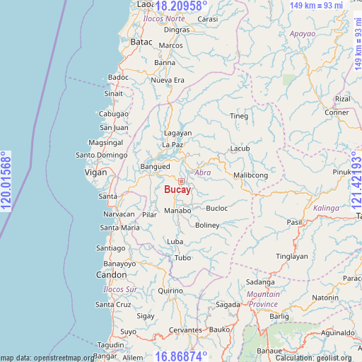
Bucay GPS coordinates[2]
17° 32' 25.44" North, 120° 43' 7.68" East
| Map corner | latitude | longitude |
|---|---|---|
| Upper-left | 18.20958°, | 120.01568° |
| Center: | 17.5404°, | 120.7188° |
| Lower-right: | 16.86874°, | 121.42193° |
| Map W x H: | 149.1×149.1 km | = 92.6×92.6mi |
| max Lat: | 20.78733° ⇑3.7% North |
| Bucay: | 17.5404° |
| min Lat: | ⇓96.3% South 4.65442° |
| min Long | Bucay | max Long |
| 117.04868° | 120.7188° | 126.58417° |
| W 15.6%⇐ | ⇒84.4% E |
Elevation
Elevation of Bucay is 96 m = 315 ft, and this is 8.1 m = 27 ft above average elevation for this country.
| Max E: |
2262 m = 7421 ft | 19.3% |
| Bucay | 96 m 315 ft | |
| Avg. | 87.9 m = 288 ft | |
Min E: |
-2 m = -7 ft | 80.7% |
See also: Philippines elevation on elevation.city.
Geographical zone
Bucay is located in North Torrid zone (between Equator and Tropic of Cancer). Distance of this Northern Tropic circle is 655.6 km =407.4 mi to North.| Distance of | km | miles | from Bucay |
|---|---|---|---|
| North Pole | 8056.8 | 5006.3 | to North |
| Arctic Circle | 5450.9 | 3387 | to North |
| Tropic Cancer | 655.6 | 407.4 | to North |
| Equator | 1950.3 | 1211.9 | to South |


Nearby cities:
15 places around Bucay: (largest is in red/bold)
• Angad
11 km =6.8 mi,  296°
296°
• Bangued
11.4 km =7.1 mi,  311°
311°
• Bantay
12.1 km =7.5 mi,  160°
160°
• Calaba
13.9 km =8.6 mi, 308°
• Dolores
12 km =7.5 mi,  355°
355°
• La Paz
15.3 km =9.5 mi,  347°
347°
• Lagangilang
8.2 km =5.1 mi,  12°
12°
• Manabo
12 km =7.5 mi,  186°
186°
• Peñarrubia
7.6 km =4.7 mi,  290°
290°
• Pidigan
14 km =8.7 mi,  283°
283°
• San Isidro
14.8 km =9.2 mi,  235°
235°
• San Juan
15.9 km =9.9 mi, 5°
• San Ramon
14.2 km =8.8 mi,  184°
184°
• Tayum
10.9 km =6.8 mi,  321°
321°
• Villaviciosa
15 km =9.3 mi,  220°
220°
Sources, notices
• [Note1] Compared only with cities in Philippines existing in our database
• [Src1] Map data: © OpenStreetMap contributors (CC-BY-SA)
• [Src2] Other city data from geonames.org with taken over terms of usage.
• [Src3] Geographical zone / Annual Mean Temperature by Robert A. Rohde @ Wikipedia
