Bangued geodata
Bangued (Cordillera) is a seat of a second-order administrative division; located in Philippines in Asia/Manila (GMT+8) time zone. In our database, there are 4166 cities with bigger population. Compared to other cities in Philippines, 96.6% of cities are located further ↓South; 86.9% of cities are located further →East and 68% of cities have lower elevation than Bangued. Note1


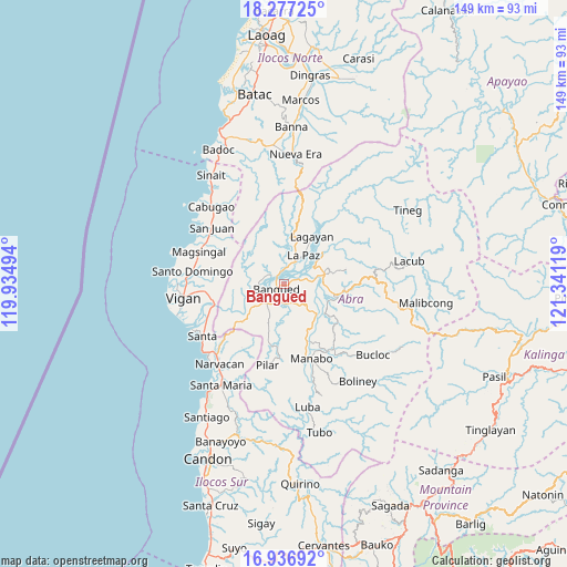
Bangued GPS coordinates[2]
17° 36' 29.988" North, 120° 38' 17.016" East
| Map corner | latitude | longitude |
|---|---|---|
| Upper-left | 18.27725°, | 119.93494° |
| Center: | 17.60833°, | 120.63806° |
| Lower-right: | 16.93692°, | 121.34119° |
| Map W x H: | 149×149 km | = 92.6×92.6mi |
| max Lat: | 20.78733° ⇑3.4% North |
| Bangued: | 17.60833° |
| min Lat: | ⇓96.6% South 4.65442° |
| min Long | Bangued | max Long |
| 117.04868° | 120.63806° | 126.58417° |
| W 13.1%⇐ | ⇒86.9% E |
Elevation
Elevation of Bangued is 48 m = 157 ft, and this is 39.9 m = 131 ft below average elevation for this country.
| Max E: |
2262 m = 7421 ft | 32% |
| Avg. | 87.9 m = 288 ft | |
| Bangued | 48 m = 157 ft | |
Min E: |
-2 m = -7 ft | 68% |
See also: Philippines elevation on elevation.city.
Geographical zone
Bangued is located in North Torrid zone (between Equator and Tropic of Cancer). Distance of this Northern Tropic circle is 648.1 km =402.7 mi to North.| Distance of | km | miles | from Bangued |
|---|---|---|---|
| North Pole | 8049.2 | 5001.5 | to North |
| Arctic Circle | 5443.3 | 3382.3 | to North |
| Tropic Cancer | 648.1 | 402.7 | to North |
| Equator | 1957.9 | 1216.6 | to South |


Nearby cities:
15 places around Bangued: (largest is in red/bold)
• Angad
2.9 km =1.8 mi,  206°
206°
• Bucay
11.4 km =7.1 mi,  131°
131°
• Calaba
2.5 km =1.6 mi,  294°
294°
• Danglas
10.5 km =6.5 mi,  10°
10°
• Dolores
8.7 km =5.4 mi,  59°
59°
• La Paz
9 km =5.6 mi,  34°
34°
• Lagangilang
10.4 km =6.5 mi,  87°
87°
• Lagayan
14.5 km =9 mi, 30°
• Langiden
8.6 km =5.3 mi,  246°
246°
• Peñarrubia
5.1 km =3.2 mi,  163°
163°
• Pidigan
6.6 km =4.1 mi,  229°
229°
• San Isidro
16.4 km =10.2 mi,  192°
192°
• San Juan
13 km =8.1 mi,  50°
50°
• San Quintin
14.5 km =9 mi,  239°
239°
• Tayum
2 km =1.2 mi, 60°
Sources, notices
• [Note1] Compared only with cities in Philippines existing in our database
• [Src1] Map data: © OpenStreetMap contributors (CC-BY-SA)
• [Src2] Other city data from geonames.org with taken over terms of usage.
• [Src3] Geographical zone / Annual Mean Temperature by Robert A. Rohde @ Wikipedia
