Calaba geodata
Calaba (Cordillera) is a populated place; located in Philippines in Asia/Manila (GMT+8) time zone. With population of 2,482 people, there are 3324 cities with bigger population in this country. Compared to other cities in Philippines, 96.8% of cities are located further ↓South; 87.6% of cities are located further →East and 72% of cities have lower elevation than Calaba. Note1


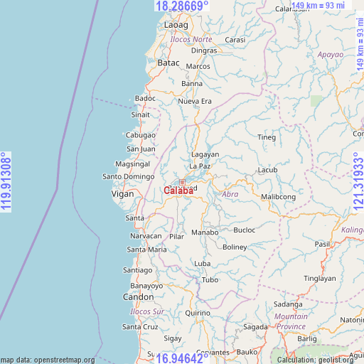
Calaba GPS coordinates[2]
17° 37' 4.08" North, 120° 36' 58.32" East
| Map corner | latitude | longitude |
|---|---|---|
| Upper-left | 18.28669°, | 119.91308° |
| Center: | 17.6178°, | 120.6162° |
| Lower-right: | 16.94642°, | 121.31933° |
| Map W x H: | 149×149 km | = 92.6×92.6mi |
| max Lat: | 20.78733° ⇑3.2% North |
| Calaba: | 17.6178° |
| min Lat: | ⇓96.8% South 4.65442° |
| min Long | Calaba | max Long |
| 117.04868° | 120.6162° | 126.58417° |
| W 12.4%⇐ | ⇒87.6% E |
Elevation
Elevation of Calaba is 57 m = 187 ft, and this is 30.9 m = 101 ft below average elevation for this country.
| Max E: |
2262 m = 7421 ft | 28% |
| Avg. | 87.9 m = 288 ft | |
| Calaba | 57 m = 187 ft | |
Min E: |
-2 m = -7 ft | 72% |
See also: Philippines elevation on elevation.city.
Geographical zone
Calaba is located in North Torrid zone (between Equator and Tropic of Cancer). Distance of this Northern Tropic circle is 647 km =402 mi to North.| Distance of | km | miles | from Calaba |
|---|---|---|---|
| North Pole | 8048.1 | 5000.9 | to North |
| Arctic Circle | 5442.3 | 3381.7 | to North |
| Tropic Cancer | 647 | 402 | to North |
| Equator | 1958.9 | 1217.2 | to South |


Nearby cities:
15 places around Calaba: (largest is in red/bold)
• Angad
3.8 km =2.4 mi,  164°
164°
• Bangued
2.5 km =1.6 mi,  114°
114°
• Bucay
13.9 km =8.6 mi,  128°
128°
• Danglas
10.1 km =6.3 mi,  24°
24°
• Dolores
10.4 km =6.5 mi,  71°
71°
• La Paz
9.8 km =6.1 mi,  49°
49°
• Lagangilang
12.7 km =7.9 mi,  92°
92°
• Lagayan
14.9 km =9.3 mi,  39°
39°
• Langiden
7.1 km =4.4 mi,  230°
230°
• Peñarrubia
7 km =4.3 mi,  147°
147°
• Pidigan
6 km =3.7 mi,  207°
207°
• San Isidro
17 km =10.6 mi,  184°
184°
• San Juan
14.3 km =8.9 mi,  59°
59°
• San Quintin
13.2 km =8.2 mi, 230°
• Tayum
4 km =2.5 mi, 90°
Sources, notices
• [Note1] Compared only with cities in Philippines existing in our database
• [Src1] Map data: © OpenStreetMap contributors (CC-BY-SA)
• [Src2] Other city data from geonames.org with taken over terms of usage.
• [Src3] Geographical zone / Annual Mean Temperature by Robert A. Rohde @ Wikipedia
