Mabini geodata
Mabini (Davao) is a seat of a third-order administrative division; located in Philippines in Asia/Manila (GMT+8) time zone. In our database, there are 4166 cities with bigger population. Compared to other cities in Philippines, 88.5% of cities are located further ↑North; 96.8% of cities are located further ←West and 57.6% of cities have higher elevation than Mabini. Note1


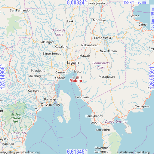
Mabini GPS coordinates[2]
7° 18' 41.004" North, 125° 51' 10.008" East
| Map corner | latitude | longitude |
|---|---|---|
| Upper-left | 8.00824°, | 125.14966° |
| Center: | 7.31139°, | 125.85278° |
| Lower-right: | 6.61345°, | 126.55591° |
| Map W x H: | 155.1×155.1 km | = 96.4×96.4mi |
| max Lat: | 20.78733° ⇑88.5% North |
| Mabini: | 7.31139° |
| min Lat: | ⇓11.5% South 4.65442° |
| min Long | Mabini | max Long |
| 117.04868° | 125.85278° | 126.58417° |
| W 96.8%⇐ | ⇒3.2% E |
Elevation
Elevation of Mabini is 18 m = 59 ft, and this is 69.9 m = 229 ft below average elevation for this country.
| Max E: |
2262 m = 7421 ft | 57.6% |
| Avg. | 87.9 m = 288 ft | |
| Mabini | 18 m = 59 ft | |
Min E: |
-2 m = -7 ft | 42.4% |
See also: Philippines elevation on elevation.city.
Geographical zone
Mabini is located in North Torrid zone (between Equator and Tropic of Cancer). Distance of Equator is 813 km =505.2 mi to South.| Distance of | km | miles | from Mabini |
|---|---|---|---|
| North Pole | 9194.1 | 5712.9 | to North |
| Arctic Circle | 6588.2 | 4093.7 | to North |
| Tropic Cancer | 1793 | 1114.1 | to North |
| Equator | 813 | 505.2 | to South |


Nearby cities:
15 places around Mabini: (largest is in red/bold)
• Bincoñgan
12.9 km =8 mi,  298°
298°
• Bungabon
10.2 km =6.3 mi,  167°
167°
• Corocotan
13.2 km =8.2 mi,  318°
318°
• Cuambog
0.6 km =0.4 mi,  239°
239°
• Dumlan
13.3 km =8.3 mi,  13°
13°
• Hiju, Maco
8.7 km =5.4 mi,  341°
341°
• La Paz
13.2 km =8.2 mi,  272°
272°
• Libuganon
9.2 km =5.7 mi, 296°
• Maco
5.6 km =3.5 mi,  2°
2°
• Magugpo Poblacion
16 km =9.9 mi, 340°
• Pandasan
3.1 km =1.9 mi,  178°
178°
• Tagdanua
12.4 km =7.7 mi,  163°
163°
• Tagnanan
3.3 km =2.1 mi,  200°
200°
• Tibagon
8.8 km =5.5 mi, 172°
• Tuganay
15.7 km =9.8 mi,  294°
294°
Sources, notices
• [Note1] Compared only with cities in Philippines existing in our database
• [Src1] Map data: © OpenStreetMap contributors (CC-BY-SA)
• [Src2] Other city data from geonames.org with taken over terms of usage.
• [Src3] Geographical zone / Annual Mean Temperature by Robert A. Rohde @ Wikipedia
