Bodega geodata
Bodega (Central Luzon) is a populated place; located in Philippines in Asia/Manila (GMT+8) time zone. With population of 2,479 people, there are 3331 cities with bigger population in this country. Compared to other cities in Philippines, 76.6% of cities are located further ↓South; 91.3% of cities are located further →East and 51.1% of cities have lower elevation than Bodega. Note1
Administrative division(s):
- Level 1: Central Luzon
- Level 2: Province of Pampanga
- Level 3: Floridablanca


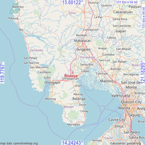
Bodega GPS coordinates[2]
14° 55' 22.44" North, 120° 28' 47.352" East
| Map corner | latitude | longitude |
|---|---|---|
| Upper-left | 15.60122°, | 119.7767° |
| Center: | 14.9229°, | 120.47982° |
| Lower-right: | 14.24243°, | 121.18295° |
| Map W x H: | 151.1×151.1 km | = 93.9×93.9mi |
| max Lat: | 20.78733° ⇑23.4% North |
| Bodega: | 14.9229° |
| min Lat: | ⇓76.6% South 4.65442° |
| min Long | Bodega | max Long |
| 117.04868° | 120.47982° | 126.58417° |
| W 8.7%⇐ | ⇒91.3% E |
Elevation
Elevation of Bodega is 24 m = 79 ft, and this is 63.9 m = 210 ft below average elevation for this country.
| Max E: |
2262 m = 7421 ft | 48.9% |
| Avg. | 87.9 m = 288 ft | |
| Bodega | 24 m = 79 ft | |
Min E: |
-2 m = -7 ft | 51.1% |
See also: Philippines elevation on elevation.city.
Geographical zone
Bodega is located in North Torrid zone (between Equator and Tropic of Cancer). Distance of this Northern Tropic circle is 946.6 km =588.2 mi to North.| Distance of | km | miles | from Bodega |
|---|---|---|---|
| North Pole | 8347.8 | 5187.1 | to North |
| Arctic Circle | 5741.9 | 3567.9 | to North |
| Tropic Cancer | 946.6 | 588.2 | to North |
| Equator | 1659.3 | 1031 | to South |


Nearby cities:
15 places around Bodega: (largest is in red/bold)
• Balsic
7.1 km =4.4 mi,  177°
177°
• Calangain
8.9 km =5.5 mi,  107°
107°
• Del Carmen
10.9 km =6.8 mi,  32°
32°
• Dinalupihan
5.8 km =3.6 mi,  210°
210°
• Floridablanca
8 km =5 mi,  40°
40°
• Gutad
1.1 km =0.7 mi,  64°
64°
• Hermosa
10.6 km =6.6 mi,  163°
163°
• Maquiapo
11 km =6.8 mi,  50°
50°
• Prado Siongco
6 km =3.7 mi,  143°
143°
• San Benito
9.8 km =6.1 mi,  215°
215°
• San Francisco
8.2 km =5.1 mi, 58°
• Santa Cruz
9.4 km =5.8 mi,  96°
96°
• Santa Teresa First
8.4 km =5.2 mi,  87°
87°
• Santiago
4 km =2.5 mi,  122°
122°
• Santo Domingo
9.5 km =5.9 mi, 60°
Sources, notices
• [Note1] Compared only with cities in Philippines existing in our database
• [Src1] Map data: © OpenStreetMap contributors (CC-BY-SA)
• [Src2] Other city data from geonames.org with taken over terms of usage.
• [Src3] Geographical zone / Annual Mean Temperature by Robert A. Rohde @ Wikipedia
