Balsic geodata
Balsic (Central Luzon) is a populated place; located in Philippines in Asia/Manila (GMT+8) time zone. With population of 5,661 people, there are 1126 cities with bigger population in this country. Compared to other cities in Philippines, 76.1% of cities are located further ↓South; 91.2% of cities are located further →East and 65.1% of cities have higher elevation than Balsic. Note1


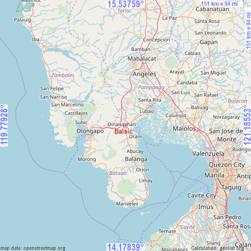
Balsic GPS coordinates[2]
14° 51' 32.616" North, 120° 28' 56.64" East
| Map corner | latitude | longitude |
|---|---|---|
| Upper-left | 15.53759°, | 119.77928° |
| Center: | 14.85906°, | 120.4824° |
| Lower-right: | 14.17839°, | 121.18553° |
| Map W x H: | 151.1×151.1 km | = 93.9×93.9mi |
| max Lat: | 20.78733° ⇑23.9% North |
| Balsic: | 14.85906° |
| min Lat: | ⇓76.1% South 4.65442° |
| min Long | Balsic | max Long |
| 117.04868° | 120.4824° | 126.58417° |
| W 8.8%⇐ | ⇒91.2% E |
Elevation
Elevation of Balsic is 14 m = 46 ft, and this is 73.9 m = 242 ft below average elevation for this country.
| Max E: |
2262 m = 7421 ft | 65.1% |
| Avg. | 87.9 m = 288 ft | |
| Balsic | 14 m = 46 ft | |
Min E: |
-2 m = -7 ft | 34.9% |
See also: Philippines elevation on elevation.city.
Geographical zone
Balsic is located in North Torrid zone (between Equator and Tropic of Cancer). Distance of this Northern Tropic circle is 953.7 km =592.6 mi to North.| Distance of | km | miles | from Balsic |
|---|---|---|---|
| North Pole | 8354.9 | 5191.5 | to North |
| Arctic Circle | 5749 | 3572.3 | to North |
| Tropic Cancer | 953.7 | 592.6 | to North |
| Equator | 1652.2 | 1026.6 | to South |


Nearby cities:
15 places around Balsic: (largest is in red/bold)
• Bodega
7.1 km =4.4 mi,  357°
357°
• Calangain
9.3 km =5.8 mi,  62°
62°
• Dinalupihan
3.9 km =2.4 mi,  303°
303°
• Floridablanca
14.1 km =8.8 mi,  20°
20°
• Gutad
7.6 km =4.7 mi,  5°
5°
• Hermosa
4.1 km =2.5 mi,  138°
138°
• Orani
8.8 km =5.5 mi, 137°
• Prado Siongco
4 km =2.5 mi, 55°
• Samal
12.1 km =7.5 mi,  147°
147°
• San Benito
6 km =3.7 mi,  262°
262°
• San Francisco
13.2 km =8.2 mi,  30°
30°
• Santa Cruz
10.8 km =6.7 mi, 56°
• Santa Teresa First
11 km =6.8 mi,  47°
47°
• Santiago
5.9 km =3.7 mi, 32°
• Santo Domingo
14.3 km =8.9 mi, 34°
Sources, notices
• [Note1] Compared only with cities in Philippines existing in our database
• [Src1] Map data: © OpenStreetMap contributors (CC-BY-SA)
• [Src2] Other city data from geonames.org with taken over terms of usage.
• [Src3] Geographical zone / Annual Mean Temperature by Robert A. Rohde @ Wikipedia
