Paraiso geodata
Paraiso (Western Visayas) is a populated place; located in Philippines in Asia/Manila (GMT+8) time zone. With population of 30,494 people, there are 271 cities with bigger population in this country. Compared to other cities in Philippines, 58.3% of cities are located further ↑North; 59.5% of cities are located further ←West and 66.7% of cities have lower elevation than Paraiso. Note1
Administrative division(s):
- Level 1: Western Visayas
- Level 2: Province of Negros Occidental
- Level 3: Sagay City


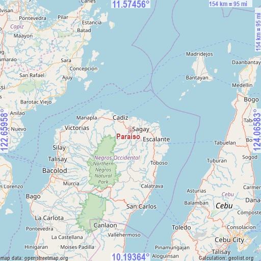
Paraiso GPS coordinates[2]
10° 53' 5.64" North, 123° 21' 45.72" East
| Map corner | latitude | longitude |
|---|---|---|
| Upper-left | 11.57456°, | 122.65958° |
| Center: | 10.8849°, | 123.3627° |
| Lower-right: | 10.19364°, | 124.06583° |
| Map W x H: | 153.5×153.5 km | = 95.4×95.4mi |
| max Lat: | 20.78733° ⇑58.3% North |
| Paraiso: | 10.8849° |
| min Lat: | ⇓41.7% South 4.65442° |
| min Long | Paraiso | max Long |
| 117.04868° | 123.3627° | 126.58417° |
| W 59.5%⇐ | ⇒40.5% E |
Elevation
Elevation of Paraiso is 45 m = 148 ft, and this is 42.9 m = 141 ft below average elevation for this country.
| Max E: |
2262 m = 7421 ft | 33.3% |
| Avg. | 87.9 m = 288 ft | |
| Paraiso | 45 m = 148 ft | |
Min E: |
-2 m = -7 ft | 66.7% |
See also: Philippines elevation on elevation.city.
Geographical zone
Paraiso is located in North Torrid zone (between Equator and Tropic of Cancer). Distance of Equator is 1210.3 km =752 mi to South.| Distance of | km | miles | from Paraiso |
|---|---|---|---|
| North Pole | 8796.8 | 5466.1 | to North |
| Arctic Circle | 6190.9 | 3846.8 | to North |
| Tropic Cancer | 1395.6 | 867.2 | to North |
| Equator | 1210.3 | 752 | to South |


Nearby cities:
15 places around Paraiso: (largest is in red/bold)
• Andres Bonifacio
12.8 km =8 mi,  286°
286°
• Bato
8.6 km =5.3 mi,  172°
172°
• Bolanon
12.6 km =7.8 mi,  73°
73°
• Bugang
16.3 km =10.1 mi, 168°
• Cadiz
10.7 km =6.6 mi,  310°
310°
• Escalante
15.7 km =9.8 mi,  108°
108°
• Lopez Jaena
7 km =4.3 mi,  126°
126°
• Luna
16.2 km =10.1 mi, 305°
• Mabini
16.6 km =10.3 mi, 126°
• Maquiling
12 km =7.5 mi,  163°
163°
• Plaridel
13.9 km =8.6 mi,  84°
84°
• Rizal
6 km =3.7 mi,  94°
94°
• Sagay
9.4 km =5.8 mi,  45°
45°
• Tamlang
12 km =7.5 mi,  123°
123°
• Tiglauigan
7.6 km =4.7 mi,  355°
355°
Sources, notices
• [Note1] Compared only with cities in Philippines existing in our database
• [Src1] Map data: © OpenStreetMap contributors (CC-BY-SA)
• [Src2] Other city data from geonames.org with taken over terms of usage.
• [Src3] Geographical zone / Annual Mean Temperature by Robert A. Rohde @ Wikipedia
