Basud geodata
Basud (Bicol) is a populated place; located in Philippines in Asia/Manila (GMT+8) time zone. With population of 2,178 people, there are 3928 cities with bigger population in this country. Compared to other cities in Philippines, 57.4% of cities are located further ↓South; 70% of cities are located further ←West and 53.5% of cities have lower elevation than Basud. Note1


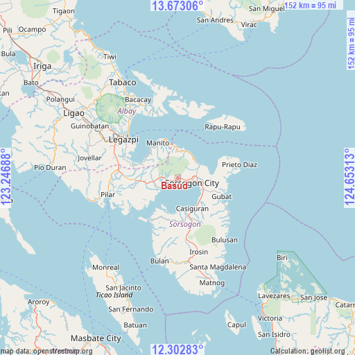
Basud GPS coordinates[2]
12° 59' 20.004" North, 123° 57' 0" East
| Map corner | latitude | longitude |
|---|---|---|
| Upper-left | 13.67306°, | 123.24688° |
| Center: | 12.98889°, | 123.95° |
| Lower-right: | 12.30283°, | 124.65313° |
| Map W x H: | 152.4×152.4 km | = 94.7×94.7mi |
| max Lat: | 20.78733° ⇑42.6% North |
| Basud: | 12.98889° |
| min Lat: | ⇓57.4% South 4.65442° |
| min Long | Basud | max Long |
| 117.04868° | 123.95° | 126.58417° |
| W 70%⇐ | ⇒30% E |
Elevation
Elevation of Basud is 26 m = 85 ft, and this is 61.9 m = 203 ft below average elevation for this country.
| Max E: |
2262 m = 7421 ft | 46.5% |
| Avg. | 87.9 m = 288 ft | |
| Basud | 26 m = 85 ft | |
Min E: |
-2 m = -7 ft | 53.5% |
See also: Philippines elevation on elevation.city.
Geographical zone
Basud is located in North Torrid zone (between Equator and Tropic of Cancer). Distance of this Northern Tropic circle is 1161.7 km =721.8 mi to North.| Distance of | km | miles | from Basud |
|---|---|---|---|
| North Pole | 8562.8 | 5320.7 | to North |
| Arctic Circle | 5956.9 | 3701.4 | to North |
| Tropic Cancer | 1161.7 | 721.8 | to North |
| Equator | 1444.2 | 897.4 | to South |


Nearby cities:
15 places around Basud: (largest is in red/bold)
• Abuyog
12 km =7.5 mi,  113°
113°
• Bacon
11.3 km =7 mi,  61°
61°
• Balete
9.5 km =5.9 mi,  69°
69°
• Boton
12.5 km =7.8 mi,  122°
122°
• Buhatan
10.7 km =6.6 mi,  97°
97°
• Capuy
1.9 km =1.2 mi,  251°
251°
• Castilla
8.6 km =5.3 mi,  238°
238°
• Gabao
7.3 km =4.5 mi,  86°
86°
• Osiao
11.9 km =7.4 mi,  16°
16°
• Pili
9.3 km =5.8 mi,  264°
264°
• Rizal
4.1 km =2.5 mi, 251°
• San Isidro
10.2 km =6.3 mi, 260°
• San Vicente
13.9 km =8.6 mi,  265°
265°
• Santo Niño
13 km =8.1 mi,  8°
8°
• Sorsogon
5 km =3.1 mi, 109°
Sources, notices
• [Note1] Compared only with cities in Philippines existing in our database
• [Src1] Map data: © OpenStreetMap contributors (CC-BY-SA)
• [Src2] Other city data from geonames.org with taken over terms of usage.
• [Src3] Geographical zone / Annual Mean Temperature by Robert A. Rohde @ Wikipedia
