Bacon geodata
Bacon (Bicol) is a seat of a third-order administrative division; located in Philippines in Asia/Manila (GMT+8) time zone. With population of 5,010 people, there are 1294 cities with bigger population in this country. Compared to other cities in Philippines, 57.6% of cities are located further ↓South; 72% of cities are located further ←West and 76.6% of cities have higher elevation than Bacon. Note1


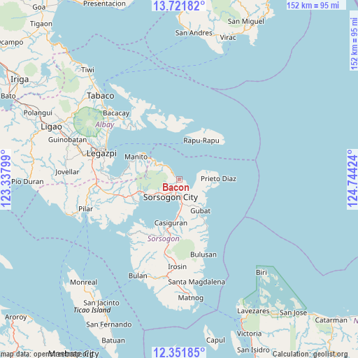
Bacon GPS coordinates[2]
13° 2' 16.008" North, 124° 2' 27.996" East
| Map corner | latitude | longitude |
|---|---|---|
| Upper-left | 13.72182°, | 123.33799° |
| Center: | 13.03778°, | 124.04111° |
| Lower-right: | 12.35185°, | 124.74424° |
| Map W x H: | 152.3×152.3 km | = 94.6×94.6mi |
| max Lat: | 20.78733° ⇑42.4% North |
| Bacon: | 13.03778° |
| min Lat: | ⇓57.6% South 4.65442° |
| min Long | Bacon | max Long |
| 117.04868° | 124.04111° | 126.58417° |
| W 72%⇐ | ⇒28% E |
Elevation
Elevation of Bacon is 10 m = 33 ft, and this is 77.9 m = 256 ft below average elevation for this country.
| Max E: |
2262 m = 7421 ft | 76.6% |
| Avg. | 87.9 m = 288 ft | |
| Bacon | 10 m = 33 ft | |
Min E: |
-2 m = -7 ft | 23.4% |
See also: Philippines elevation on elevation.city.
Geographical zone
Bacon is located in North Torrid zone (between Equator and Tropic of Cancer). Distance of this Northern Tropic circle is 1156.3 km =718.5 mi to North.| Distance of | km | miles | from Bacon |
|---|---|---|---|
| North Pole | 8557.4 | 5317.3 | to North |
| Arctic Circle | 5951.5 | 3698.1 | to North |
| Tropic Cancer | 1156.3 | 718.5 | to North |
| Equator | 1449.7 | 900.8 | to South |


Nearby cities:
15 places around Bacon: (largest is in red/bold)
• Abuyog
10.3 km =6.4 mi,  173°
173°
• Bagacay
12.5 km =7.8 mi,  119°
119°
• Balete
2.3 km =1.4 mi,  205°
205°
• Basud
11.3 km =7 mi,  241°
241°
• Boton
12.2 km =7.6 mi,  176°
176°
• Buhatan
7 km =4.3 mi, 174°
• Capuy
13.2 km =8.2 mi, 242°
• Carriedo
13.4 km =8.3 mi,  148°
148°
• Gabao
5.7 km =3.5 mi, 207°
• Gubat
15.8 km =9.8 mi, 145°
• Osiao
8.8 km =5.5 mi,  312°
312°
• Rizal
15.3 km =9.5 mi, 243°
• Santo Niño
10.8 km =6.7 mi, 313°
• Sorsogon
8.8 km =5.5 mi,  216°
216°
• Sugod
7.1 km =4.4 mi,  142°
142°
Sources, notices
• [Note1] Compared only with cities in Philippines existing in our database
• [Src1] Map data: © OpenStreetMap contributors (CC-BY-SA)
• [Src2] Other city data from geonames.org with taken over terms of usage.
• [Src3] Geographical zone / Annual Mean Temperature by Robert A. Rohde @ Wikipedia
