Manacsac geodata
Manacsac (Central Luzon) is a populated place; located in Philippines in Asia/Manila (GMT+8) time zone. With population of 2,313 people, there are 3646 cities with bigger population in this country. Compared to other cities in Philippines, 82.7% of cities are located further ↓South; 82.5% of cities are located further →East and 62.2% of cities have lower elevation than Manacsac. Note1


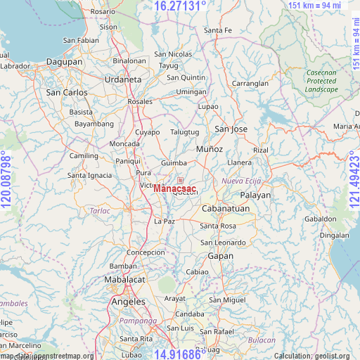
Manacsac GPS coordinates[2]
15° 35' 42.72" North, 120° 47' 27.96" East
| Map corner | latitude | longitude |
|---|---|---|
| Upper-left | 16.27131°, | 120.08798° |
| Center: | 15.5952°, | 120.7911° |
| Lower-right: | 14.91686°, | 121.49423° |
| Map W x H: | 150.6×150.6 km | = 93.6×93.6mi |
| max Lat: | 20.78733° ⇑17.3% North |
| Manacsac: | 15.5952° |
| min Lat: | ⇓82.7% South 4.65442° |
| min Long | Manacsac | max Long |
| 117.04868° | 120.7911° | 126.58417° |
| W 17.5%⇐ | ⇒82.5% E |
Elevation
Elevation of Manacsac is 37 m = 121 ft, and this is 50.9 m = 167 ft below average elevation for this country.
| Max E: |
2262 m = 7421 ft | 37.8% |
| Avg. | 87.9 m = 288 ft | |
| Manacsac | 37 m = 121 ft | |
Min E: |
-2 m = -7 ft | 62.2% |
See also: Philippines elevation on elevation.city.
Geographical zone
Manacsac is located in North Torrid zone (between Equator and Tropic of Cancer). Distance of this Northern Tropic circle is 871.9 km =541.8 mi to North.| Distance of | km | miles | from Manacsac |
|---|---|---|---|
| North Pole | 8273 | 5140.6 | to North |
| Arctic Circle | 5667.2 | 3521.4 | to North |
| Tropic Cancer | 871.9 | 541.8 | to North |
| Equator | 1734 | 1077.5 | to South |


Nearby cities:
15 places around Manacsac: (largest is in red/bold)
• Bunol
9.2 km =5.7 mi,  30°
30°
• Calibungan
7.2 km =4.5 mi,  272°
272°
• Cawayan Bugtong
4.5 km =2.8 mi,  340°
340°
• Guimba
7.7 km =4.8 mi, 341°
• Licab
6.4 km =4 mi,  207°
207°
• Maturanoc
6.9 km =4.3 mi,  0°
0°
• Nagpandayan
2.5 km =1.6 mi,  286°
286°
• Quezon
5.5 km =3.4 mi,  152°
152°
• San Alejandro
7.3 km =4.5 mi,  121°
121°
• San Casimiro
4.8 km =3 mi,  193°
193°
• San Cristobal
5.3 km =3.3 mi, 209°
• Santa Maria
8 km =5 mi,  178°
178°
• Santa Rita
8.8 km =5.5 mi,  72°
72°
• Santo Domingo
9.2 km =5.7 mi,  95°
95°
• Villarosa
6.7 km =4.2 mi,  221°
221°
Sources, notices
• [Note1] Compared only with cities in Philippines existing in our database
• [Src1] Map data: © OpenStreetMap contributors (CC-BY-SA)
• [Src2] Other city data from geonames.org with taken over terms of usage.
• [Src3] Geographical zone / Annual Mean Temperature by Robert A. Rohde @ Wikipedia
