Bagombong geodata
Bagombong (Calabarzon) is a populated place; located in Philippines in Asia/Manila (GMT+8) time zone. With population of 2,984 people, there are 2545 cities with bigger population in this country. Compared to other cities in Philippines, 73.2% of cities are located further ↓South; 69% of cities are located further →East and 80.7% of cities have higher elevation than Bagombong. Note1


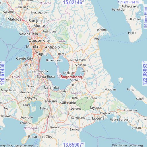
Bagombong GPS coordinates[2]
14° 20' 28.68" North, 121° 22' 39" East
| Map corner | latitude | longitude |
|---|---|---|
| Upper-left | 15.02146°, | 120.67438° |
| Center: | 14.3413°, | 121.3775° |
| Lower-right: | 13.65907°, | 122.08063° |
| Map W x H: | 151.5×151.5 km | = 94.1×94.1mi |
| max Lat: | 20.78733° ⇑26.8% North |
| Bagombong: | 14.3413° |
| min Lat: | ⇓73.2% South 4.65442° |
| min Long | Bagombong | max Long |
| 117.04868° | 121.3775° | 126.58417° |
| W 31%⇐ | ⇒69% E |
Elevation
Elevation of Bagombong is 9 m = 30 ft, and this is 78.9 m = 259 ft below average elevation for this country.
| Max E: |
2262 m = 7421 ft | 80.7% |
| Avg. | 87.9 m = 288 ft | |
| Bagombong | 9 m = 30 ft | |
Min E: |
-2 m = -7 ft | 19.3% |
See also: Philippines elevation on elevation.city.
Geographical zone
Bagombong is located in North Torrid zone (between Equator and Tropic of Cancer). Distance of this Northern Tropic circle is 1011.3 km =628.4 mi to North.| Distance of | km | miles | from Bagombong |
|---|---|---|---|
| North Pole | 8412.5 | 5227.3 | to North |
| Arctic Circle | 5806.6 | 3608.1 | to North |
| Tropic Cancer | 1011.3 | 628.4 | to North |
| Equator | 1594.6 | 990.8 | to South |


Nearby cities:
15 places around Bagombong: (largest is in red/bold)
• Jalajala
6.1 km =3.8 mi,  282°
282°
• Kabulusan
3.3 km =2.1 mi,  47°
47°
• Lumbang
10.1 km =6.3 mi,  118°
118°
• Mabitac
10.9 km =6.8 mi,  30°
30°
• Malaya
7.5 km =4.7 mi,  325°
325°
• Maulawin
10.2 km =6.3 mi,  144°
144°
• Paagahan
11.8 km =7.3 mi,  12°
12°
• Paete
11.6 km =7.2 mi,  77°
77°
• Pagsanjan
11.3 km =7 mi,  132°
132°
• Pangil
11.7 km =7.3 mi, 53°
• Punta
9.4 km =5.8 mi,  233°
233°
• Quisao
11.4 km =7.1 mi,  335°
335°
• Santa Cruz
7.9 km =4.9 mi,  148°
148°
• Siniloan
11.6 km =7.2 mi,  39°
39°
• Wawa
9.9 km =6.2 mi, 116°
Sources, notices
• [Note1] Compared only with cities in Philippines existing in our database
• [Src1] Map data: © OpenStreetMap contributors (CC-BY-SA)
• [Src2] Other city data from geonames.org with taken over terms of usage.
• [Src3] Geographical zone / Annual Mean Temperature by Robert A. Rohde @ Wikipedia
