Jalajala geodata
Jalajala (Calabarzon) is a seat of a third-order administrative division; located in Philippines in Asia/Manila (GMT+8) time zone. With population of 16,400 people, there are 419 cities with bigger population in this country. Compared to other cities in Philippines, 73.4% of cities are located further ↓South; 69.8% of cities are located further →East and 80.7% of cities have higher elevation than Jalajala. Note1


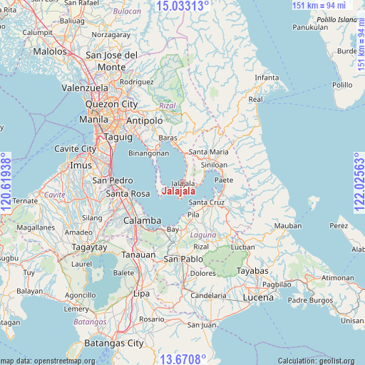
Jalajala GPS coordinates[2]
14° 21' 10.8" North, 121° 19' 21" East
| Map corner | latitude | longitude |
|---|---|---|
| Upper-left | 15.03313°, | 120.61938° |
| Center: | 14.353°, | 121.3225° |
| Lower-right: | 13.6708°, | 122.02563° |
| Map W x H: | 151.5×151.5 km | = 94.1×94.1mi |
| max Lat: | 20.78733° ⇑26.6% North |
| Jalajala: | 14.353° |
| min Lat: | ⇓73.4% South 4.65442° |
| min Long | Jalajala | max Long |
| 117.04868° | 121.3225° | 126.58417° |
| W 30.2%⇐ | ⇒69.8% E |
Elevation
Elevation of Jalajala is 9 m = 30 ft, and this is 78.9 m = 259 ft below average elevation for this country.
| Max E: |
2262 m = 7421 ft | 80.7% |
| Avg. | 87.9 m = 288 ft | |
| Jalajala | 9 m = 30 ft | |
Min E: |
-2 m = -7 ft | 19.3% |
See also: Philippines elevation on elevation.city.
Geographical zone
Jalajala is located in North Torrid zone (between Equator and Tropic of Cancer). Distance of this Northern Tropic circle is 1010 km =627.6 mi to North.| Distance of | km | miles | from Jalajala |
|---|---|---|---|
| North Pole | 8411.2 | 5226.5 | to North |
| Arctic Circle | 5805.3 | 3607.2 | to North |
| Tropic Cancer | 1010 | 627.6 | to North |
| Equator | 1595.9 | 991.6 | to South |


Nearby cities:
15 places around Jalajala: (largest is in red/bold)
• Bagombong
6.1 km =3.8 mi,  102°
102°
• Gulod
11.3 km =7 mi,  265°
265°
• Kabulusan
8.4 km =5.2 mi,  83°
83°
• Mabitac
14 km =8.7 mi,  54°
54°
• Malaya
5.2 km =3.2 mi,  19°
19°
• Maulawin
15.3 km =9.5 mi,  128°
128°
• Navotas
12.5 km =7.8 mi,  304°
304°
• Paagahan
13.2 km =8.2 mi,  39°
39°
• Pila
14.2 km =8.8 mi,  161°
161°
• Pililla
14.8 km =9.2 mi,  353°
353°
• Punta
7 km =4.3 mi,  193°
193°
• Quisao
9.2 km =5.7 mi,  8°
8°
• Santa Cruz
12.8 km =8 mi, 128°
• Siniloan
15.4 km =9.6 mi,  60°
60°
• Victoria
14 km =8.7 mi,  177°
177°
Sources, notices
• [Note1] Compared only with cities in Philippines existing in our database
• [Src1] Map data: © OpenStreetMap contributors (CC-BY-SA)
• [Src2] Other city data from geonames.org with taken over terms of usage.
• [Src3] Geographical zone / Annual Mean Temperature by Robert A. Rohde @ Wikipedia
