Punta geodata
Punta (Calabarzon) is a populated place; located in Philippines in Asia/Manila (GMT+8) time zone. With population of 2,577 people, there are 3148 cities with bigger population in this country. Compared to other cities in Philippines, 72.8% of cities are located further ↓South; 70% of cities are located further →East and 95.5% of cities have higher elevation than Punta. Note1


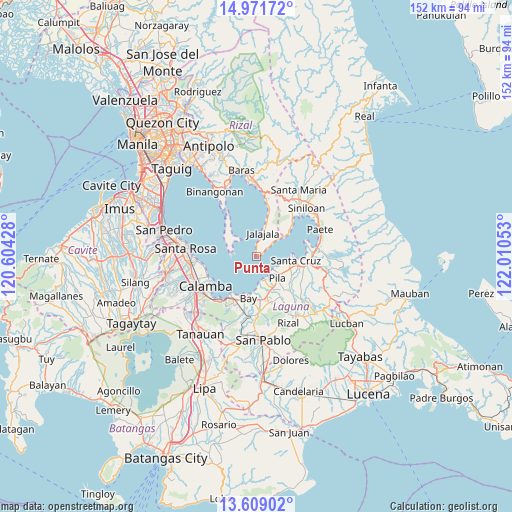
Punta GPS coordinates[2]
14° 17' 29.04" North, 121° 18' 26.64" East
| Map corner | latitude | longitude |
|---|---|---|
| Upper-left | 14.97172°, | 120.60428° |
| Center: | 14.2914°, | 121.3074° |
| Lower-right: | 13.60902°, | 122.01053° |
| Map W x H: | 151.5×151.5 km | = 94.1×94.1mi |
| max Lat: | 20.78733° ⇑27.2% North |
| Punta: | 14.2914° |
| min Lat: | ⇓72.8% South 4.65442° |
| min Long | Punta | max Long |
| 117.04868° | 121.3074° | 126.58417° |
| W 30%⇐ | ⇒70% E |
Elevation
Elevation of Punta is 5 m = 16 ft, and this is 82.9 m = 272 ft below average elevation for this country.
| Max E: |
2262 m = 7421 ft | 95.5% |
| Avg. | 87.9 m = 288 ft | |
| Punta | 5 m = 16 ft | |
Min E: |
-2 m = -7 ft | 4.5% |
See also: Philippines elevation on elevation.city.
Geographical zone
Punta is located in North Torrid zone (between Equator and Tropic of Cancer). Distance of this Northern Tropic circle is 1016.9 km =631.9 mi to North.| Distance of | km | miles | from Punta |
|---|---|---|---|
| North Pole | 8418 | 5230.7 | to North |
| Arctic Circle | 5812.1 | 3611.5 | to North |
| Tropic Cancer | 1016.9 | 631.9 | to North |
| Equator | 1589.1 | 987.4 | to South |


Nearby cities:
15 places around Punta: (largest is in red/bold)
• Bagombong
9.4 km =5.8 mi,  53°
53°
• Bay
12.2 km =7.6 mi,  191°
191°
• Dayap
12.7 km =7.9 mi,  167°
167°
• Gulod
11.3 km =7 mi,  301°
301°
• Hanggan
11.4 km =7.1 mi,  183°
183°
• Jalajala
7 km =4.3 mi,  13°
13°
• Kabulusan
12.7 km =7.9 mi, 52°
• Malaya
12.2 km =7.6 mi,  15°
15°
• Masapang
11.1 km =6.9 mi,  160°
160°
• Maulawin
13.8 km =8.6 mi,  101°
101°
• Pila
9 km =5.6 mi,  136°
136°
• San Isidro
13.4 km =8.3 mi,  133°
133°
• San Miguel
12.3 km =7.6 mi, 144°
• Santa Cruz
11.8 km =7.3 mi, 95°
• Victoria
7.5 km =4.7 mi, 161°
Sources, notices
• [Note1] Compared only with cities in Philippines existing in our database
• [Src1] Map data: © OpenStreetMap contributors (CC-BY-SA)
• [Src2] Other city data from geonames.org with taken over terms of usage.
• [Src3] Geographical zone / Annual Mean Temperature by Robert A. Rohde @ Wikipedia
