Bacarra geodata
Bacarra (Ilocos) is a seat of a third-order administrative division; located in Philippines in Asia/Manila (GMT+8) time zone. With population of 9,636 people, there are 641 cities with bigger population in this country. Compared to other cities in Philippines, 99.1% of cities are located further ↓South; 87.6% of cities are located further →East and 56.1% of cities have higher elevation than Bacarra. Note1


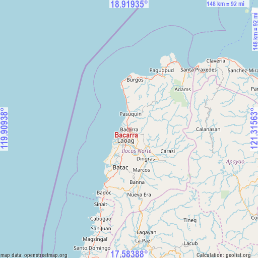
Bacarra GPS coordinates[2]
18° 15' 10.44" North, 120° 36' 45" East
| Map corner | latitude | longitude |
|---|---|---|
| Upper-left | 18.91935°, | 119.90938° |
| Center: | 18.2529°, | 120.6125° |
| Lower-right: | 17.58388°, | 121.31563° |
| Map W x H: | 148.5×148.5 km | = 92.3×92.3mi |
| max Lat: | 20.78733° ⇑0.9% North |
| Bacarra: | 18.2529° |
| min Lat: | ⇓99.1% South 4.65442° |
| min Long | Bacarra | max Long |
| 117.04868° | 120.6125° | 126.58417° |
| W 12.4%⇐ | ⇒87.6% E |
Elevation
Elevation of Bacarra is 19 m = 62 ft, and this is 68.9 m = 226 ft below average elevation for this country.
| Max E: |
2262 m = 7421 ft | 56.1% |
| Avg. | 87.9 m = 288 ft | |
| Bacarra | 19 m = 62 ft | |
Min E: |
-2 m = -7 ft | 43.9% |
See also: Philippines elevation on elevation.city.
Geographical zone
Bacarra is located in North Torrid zone (between Equator and Tropic of Cancer). Distance of this Northern Tropic circle is 576.4 km =358.2 mi to North.| Distance of | km | miles | from Bacarra |
|---|---|---|---|
| North Pole | 7977.5 | 4957 | to North |
| Arctic Circle | 5371.6 | 3337.8 | to North |
| Tropic Cancer | 576.4 | 358.2 | to North |
| Equator | 2029.5 | 1261.1 | to South |


Nearby cities:
15 places around Bacarra: (largest is in red/bold)
• Baay
15.4 km =9.6 mi,  194°
194°
• Batac City
22.5 km =14 mi, 192°
• Bil-Loca
19 km =11.8 mi, 194°
• Dingras
18.9 km =11.7 mi,  151°
151°
• Laoag
6.4 km =4 mi,  196°
196°
• Marcos
23.8 km =14.8 mi,  159°
159°
• Nagbacalan
17.9 km =11.1 mi,  211°
211°
• Paoay
23.3 km =14.5 mi, 204°
• Pasuquin
8.9 km =5.5 mi,  3°
3°
• Piddig
14.7 km =9.1 mi,  131°
131°
• Quiling
21.8 km =13.5 mi, 199°
• San Lorenzo
13.5 km =8.4 mi,  171°
171°
• San Nicolas
9.1 km =5.7 mi, 191°
• Sarrat
11.2 km =7 mi, 161°
• Vintar
4.6 km =2.9 mi, 126°
Sources, notices
• [Note1] Compared only with cities in Philippines existing in our database
• [Src1] Map data: © OpenStreetMap contributors (CC-BY-SA)
• [Src2] Other city data from geonames.org with taken over terms of usage.
• [Src3] Geographical zone / Annual Mean Temperature by Robert A. Rohde @ Wikipedia
