Arenas geodata
Arenas (Central Luzon) is a populated place; located in Philippines in Asia/Manila (GMT+8) time zone. With population of 4,108 people, there are 1664 cities with bigger population in this country. Compared to other cities in Philippines, 79.1% of cities are located further ↓South; 85.3% of cities are located further →East and 62.2% of cities have lower elevation than Arenas. Note1


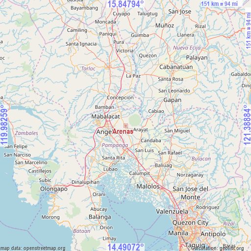
Arenas GPS coordinates[2]
15° 10' 13.512" North, 120° 41' 8.556" East
| Map corner | latitude | longitude |
|---|---|---|
| Upper-left | 15.84794°, | 119.98259° |
| Center: | 15.17042°, | 120.68571° |
| Lower-right: | 14.49072°, | 121.38884° |
| Map W x H: | 150.9×150.9 km | = 93.8×93.8mi |
| max Lat: | 20.78733° ⇑20.9% North |
| Arenas: | 15.17042° |
| min Lat: | ⇓79.1% South 4.65442° |
| min Long | Arenas | max Long |
| 117.04868° | 120.68571° | 126.58417° |
| W 14.7%⇐ | ⇒85.3% E |
Elevation
Elevation of Arenas is 37 m = 121 ft, and this is 50.9 m = 167 ft below average elevation for this country.
| Max E: |
2262 m = 7421 ft | 37.8% |
| Avg. | 87.9 m = 288 ft | |
| Arenas | 37 m = 121 ft | |
Min E: |
-2 m = -7 ft | 62.2% |
See also: Philippines elevation on elevation.city.
Geographical zone
Arenas is located in North Torrid zone (between Equator and Tropic of Cancer). Distance of this Northern Tropic circle is 919.1 km =571.1 mi to North.| Distance of | km | miles | from Arenas |
|---|---|---|---|
| North Pole | 8320.3 | 5170 | to North |
| Arctic Circle | 5714.4 | 3550.8 | to North |
| Tropic Cancer | 919.1 | 571.1 | to North |
| Equator | 1686.8 | 1048.1 | to South |


Nearby cities:
15 places around Arenas: (largest is in red/bold)
• Acli
6.9 km =4.3 mi,  219°
219°
• Anao
3.3 km =2.1 mi,  169°
169°
• Arayat
9.3 km =5.8 mi,  103°
103°
• Buensuseso
2.9 km =1.8 mi,  332°
332°
• Cauayan
2.6 km =1.6 mi, 215°
• Culubasa
4.6 km =2.9 mi,  231°
231°
• Magalang
5.7 km =3.5 mi, 330°
• Malino
5 km =3.1 mi,  194°
194°
• Pandacaqui
3.3 km =2.1 mi,  272°
272°
• Panlinlang
2.1 km =1.3 mi,  46°
46°
• San Antonio
2 km =1.2 mi, 172°
• San Isidro
8.6 km =5.3 mi, 326°
• San Patricio
9.3 km =5.8 mi,  150°
150°
• Santo Niño
7.9 km =4.9 mi,  20°
20°
• Tal I Mun Doc
4.6 km =2.9 mi,  358°
358°
Sources, notices
• [Note1] Compared only with cities in Philippines existing in our database
• [Src1] Map data: © OpenStreetMap contributors (CC-BY-SA)
• [Src2] Other city data from geonames.org with taken over terms of usage.
• [Src3] Geographical zone / Annual Mean Temperature by Robert A. Rohde @ Wikipedia
