Malino geodata
Malino (Central Luzon) is a populated place; located in Philippines in Asia/Manila (GMT+8) time zone. With population of 4,979 people, there are 1306 cities with bigger population in this country. Compared to other cities in Philippines, 78.7% of cities are located further ↓South; 85.6% of cities are located further →East and 61.5% of cities have lower elevation than Malino. Note1


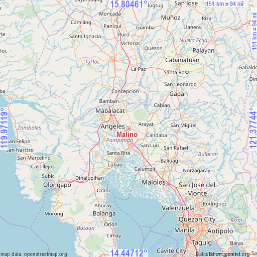
Malino GPS coordinates[2]
15° 7' 37.02" North, 120° 40' 27.516" East
| Map corner | latitude | longitude |
|---|---|---|
| Upper-left | 15.80461°, | 119.97119° |
| Center: | 15.12695°, | 120.67431° |
| Lower-right: | 14.44712°, | 121.37744° |
| Map W x H: | 150.9×150.9 km | = 93.8×93.8mi |
| max Lat: | 20.78733° ⇑21.3% North |
| Malino: | 15.12695° |
| min Lat: | ⇓78.7% South 4.65442° |
| min Long | Malino | max Long |
| 117.04868° | 120.67431° | 126.58417° |
| W 14.4%⇐ | ⇒85.6% E |
Elevation
Elevation of Malino is 36 m = 118 ft, and this is 51.9 m = 170 ft below average elevation for this country.
| Max E: |
2262 m = 7421 ft | 38.5% |
| Avg. | 87.9 m = 288 ft | |
| Malino | 36 m = 118 ft | |
Min E: |
-2 m = -7 ft | 61.5% |
See also: Philippines elevation on elevation.city.
Geographical zone
Malino is located in North Torrid zone (between Equator and Tropic of Cancer). Distance of this Northern Tropic circle is 924 km =574.1 mi to North.| Distance of | km | miles | from Malino |
|---|---|---|---|
| North Pole | 8325.1 | 5173 | to North |
| Arctic Circle | 5719.2 | 3553.7 | to North |
| Tropic Cancer | 924 | 574.1 | to North |
| Equator | 1682 | 1045.1 | to South |


Nearby cities:
15 places around Malino: (largest is in red/bold)
• Acli
3.2 km =2 mi,  261°
261°
• Anao
2.4 km =1.5 mi,  48°
48°
• Arenas
5 km =3.1 mi,  14°
14°
• Balibago
9.3 km =5.8 mi,  294°
294°
• Buensuseso
7.4 km =4.6 mi,  359°
359°
• Bulaon
5.1 km =3.2 mi,  193°
193°
• Calibutbut
8.3 km =5.2 mi, 260°
• Cauayan
2.7 km =1.7 mi,  354°
354°
• Culubasa
3.1 km =1.9 mi,  309°
309°
• Mexico
8.5 km =5.3 mi,  144°
144°
• Pandacaqui
5.4 km =3.4 mi,  337°
337°
• Panlinlang
6.8 km =4.2 mi,  23°
23°
• San Antonio
3.2 km =2 mi,  27°
27°
• San Patricio
6.7 km =4.2 mi,  119°
119°
• Telabastagan
7.2 km =4.5 mi, 262°
Sources, notices
• [Note1] Compared only with cities in Philippines existing in our database
• [Src1] Map data: © OpenStreetMap contributors (CC-BY-SA)
• [Src2] Other city data from geonames.org with taken over terms of usage.
• [Src3] Geographical zone / Annual Mean Temperature by Robert A. Rohde @ Wikipedia
