Alua geodata
Alua (Central Luzon) is a populated place; located in Philippines in Asia/Manila (GMT+8) time zone. With population of 4,943 people, there are 1317 cities with bigger population in this country. Compared to other cities in Philippines, 79.9% of cities are located further ↓South; 79.6% of cities are located further →East and 50.3% of cities have higher elevation than Alua. Note1
Administrative division(s):
- Level 1: Central Luzon
- Level 2: Province of Nueva Ecija
- Level 3: San Isidro


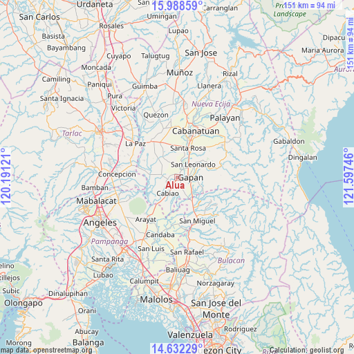
Alua GPS coordinates[2]
15° 18' 41.544" North, 120° 53' 39.588" East
| Map corner | latitude | longitude |
|---|---|---|
| Upper-left | 15.98859°, | 120.19121° |
| Center: | 15.31154°, | 120.89433° |
| Lower-right: | 14.63229°, | 121.59746° |
| Map W x H: | 150.8×150.8 km | = 93.7×93.7mi |
| max Lat: | 20.78733° ⇑20.1% North |
| Alua: | 15.31154° |
| min Lat: | ⇓79.9% South 4.65442° |
| min Long | Alua | max Long |
| 117.04868° | 120.89433° | 126.58417° |
| W 20.4%⇐ | ⇒79.6% E |
Elevation
Elevation of Alua is 23 m = 75 ft, and this is 64.9 m = 213 ft below average elevation for this country.
| Max E: |
2262 m = 7421 ft | 50.3% |
| Avg. | 87.9 m = 288 ft | |
| Alua | 23 m = 75 ft | |
Min E: |
-2 m = -7 ft | 49.7% |
See also: Philippines elevation on elevation.city.
Geographical zone
Alua is located in North Torrid zone (between Equator and Tropic of Cancer). Distance of this Northern Tropic circle is 903.4 km =561.3 mi to North.| Distance of | km | miles | from Alua |
|---|---|---|---|
| North Pole | 8304.6 | 5160.2 | to North |
| Arctic Circle | 5698.7 | 3541 | to North |
| Tropic Cancer | 903.4 | 561.3 | to North |
| Equator | 1702.5 | 1057.9 | to South |


Nearby cities:
15 places around Alua: (largest is in red/bold)
• Buliran Segundo
5.8 km =3.6 mi,  210°
210°
• Calaba
2.5 km =1.6 mi,  240°
240°
• Entablado
4.4 km =2.7 mi,  230°
230°
• Gapan
5.6 km =3.5 mi,  94°
94°
• Jaen
3.2 km =2 mi,  56°
56°
• Lawang Kupang
5.7 km =3.5 mi,  315°
315°
• Nieves
6.1 km =3.8 mi,  72°
72°
• Papaya
6.4 km =4 mi,  278°
278°
• San Anton
4.9 km =3 mi,  34°
34°
• San Antonio
4.2 km =2.6 mi,  261°
261°
• San Mariano
2.2 km =1.4 mi,  297°
297°
• Santa Cruz
4.4 km =2.7 mi,  265°
265°
• Santo Cristo
1.7 km =1.1 mi,  194°
194°
• Tabon
4.9 km =3 mi,  156°
156°
• Tikiw
3.6 km =2.2 mi, 270°
Sources, notices
• [Note1] Compared only with cities in Philippines existing in our database
• [Src1] Map data: © OpenStreetMap contributors (CC-BY-SA)
• [Src2] Other city data from geonames.org with taken over terms of usage.
• [Src3] Geographical zone / Annual Mean Temperature by Robert A. Rohde @ Wikipedia
