Gapan geodata
Gapan (Central Luzon) is a seat of a third-order administrative division; located in Philippines in Asia/Manila (GMT+8) time zone. With population of 79,064 people, there are 116 cities with bigger population in this country. Compared to other cities in Philippines, 79.9% of cities are located further ↓South; 77.9% of cities are located further →East and 51.1% of cities have lower elevation than Gapan. Note1
Administrative division(s):
- Level 1: Central Luzon
- Level 2: Province of Nueva Ecija
- Level 3: City of Gapan


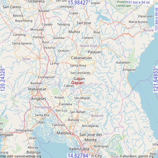
Gapan GPS coordinates[2]
15° 18' 25.92" North, 120° 56' 47.04" East
| Map corner | latitude | longitude |
|---|---|---|
| Upper-left | 15.98427°, | 120.24328° |
| Center: | 15.3072°, | 120.9464° |
| Lower-right: | 14.62794°, | 121.64953° |
| Map W x H: | 150.8×150.8 km | = 93.7×93.7mi |
| max Lat: | 20.78733° ⇑20.1% North |
| Gapan: | 15.3072° |
| min Lat: | ⇓79.9% South 4.65442° |
| min Long | Gapan | max Long |
| 117.04868° | 120.9464° | 126.58417° |
| W 22.1%⇐ | ⇒77.9% E |
Elevation
Elevation of Gapan is 24 m = 79 ft, and this is 63.9 m = 210 ft below average elevation for this country.
| Max E: |
2262 m = 7421 ft | 48.9% |
| Avg. | 87.9 m = 288 ft | |
| Gapan | 24 m = 79 ft | |
Min E: |
-2 m = -7 ft | 51.1% |
See also: Gapan elevation on elevation.city.
Geographical zone
Gapan is located in North Torrid zone (between Equator and Tropic of Cancer). Distance of this Northern Tropic circle is 903.9 km =561.7 mi to North.| Distance of | km | miles | from Gapan |
|---|---|---|---|
| North Pole | 8305.1 | 5160.5 | to North |
| Arctic Circle | 5699.2 | 3541.3 | to North |
| Tropic Cancer | 903.9 | 561.7 | to North |
| Equator | 1702 | 1057.6 | to South |


Nearby cities:
15 places around Gapan: (largest is in red/bold)
• Alua
5.6 km =3.5 mi,  274°
274°
• Calaba
7.8 km =4.8 mi,  264°
264°
• Entablado
9.2 km =5.7 mi, 255°
• Jaen
3.7 km =2.3 mi,  307°
307°
• Mangga
7.5 km =4.7 mi,  212°
212°
• Nieves
2.4 km =1.5 mi,  6°
6°
• Peñaranda
7.9 km =4.9 mi,  51°
51°
• Pulo
7.1 km =4.4 mi,  195°
195°
• San Anton
5.3 km =3.3 mi,  327°
327°
• San Leonardo
6.5 km =4 mi,  16°
16°
• San Mariano
7.7 km =4.8 mi,  281°
281°
• Santo Cristo
6.1 km =3.8 mi, 259°
• Tabon
5.4 km =3.4 mi,  221°
221°
• Tabuating
9.5 km =5.9 mi,  356°
356°
• Tikiw
9.2 km =5.7 mi, 273°
Sources, notices
• [Note1] Compared only with cities in Philippines existing in our database
• [Src1] Map data: © OpenStreetMap contributors (CC-BY-SA)
• [Src2] Other city data from geonames.org with taken over terms of usage.
• [Src3] Geographical zone / Annual Mean Temperature by Robert A. Rohde @ Wikipedia
