Nieves geodata
Nieves (Central Luzon) is a populated place; located in Philippines in Asia/Manila (GMT+8) time zone. With population of 8,617 people, there are 718 cities with bigger population in this country. Compared to other cities in Philippines, 80.1% of cities are located further ↓South; 77.8% of cities are located further →East and 54.4% of cities have lower elevation than Nieves. Note1
Administrative division(s):
- Level 1: Central Luzon
- Level 2: Province of Nueva Ecija
- Level 3: San Leonardo


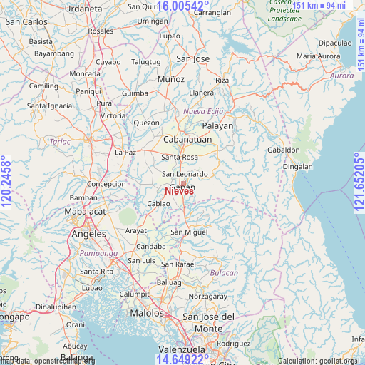
Nieves GPS coordinates[2]
15° 19' 42.312" North, 120° 56' 56.112" East
| Map corner | latitude | longitude |
|---|---|---|
| Upper-left | 16.00542°, | 120.2458° |
| Center: | 15.32842°, | 120.94892° |
| Lower-right: | 14.64922°, | 121.65205° |
| Map W x H: | 150.8×150.8 km | = 93.7×93.7mi |
| max Lat: | 20.78733° ⇑19.9% North |
| Nieves: | 15.32842° |
| min Lat: | ⇓80.1% South 4.65442° |
| min Long | Nieves | max Long |
| 117.04868° | 120.94892° | 126.58417° |
| W 22.2%⇐ | ⇒77.8% E |
Elevation
Elevation of Nieves is 27 m = 89 ft, and this is 60.9 m = 200 ft below average elevation for this country.
| Max E: |
2262 m = 7421 ft | 45.6% |
| Avg. | 87.9 m = 288 ft | |
| Nieves | 27 m = 89 ft | |
Min E: |
-2 m = -7 ft | 54.4% |
See also: Philippines elevation on elevation.city.
Geographical zone
Nieves is located in North Torrid zone (between Equator and Tropic of Cancer). Distance of this Northern Tropic circle is 901.6 km =560.2 mi to North.| Distance of | km | miles | from Nieves |
|---|---|---|---|
| North Pole | 8302.7 | 5159.1 | to North |
| Arctic Circle | 5696.8 | 3539.8 | to North |
| Tropic Cancer | 901.6 | 560.2 | to North |
| Equator | 1704.4 | 1059.1 | to South |


Nearby cities:
15 places around Nieves: (largest is in red/bold)
• Alua
6.1 km =3.8 mi,  252°
252°
• Calaba
8.6 km =5.3 mi, 248°
• Gapan
2.4 km =1.5 mi,  186°
186°
• Jaen
3.2 km =2 mi,  268°
268°
• Mangga
9.7 km =6 mi,  206°
206°
• Peñaranda
6.4 km =4 mi,  66°
66°
• Pulo
9.4 km =5.8 mi, 193°
• Putlod
9.9 km =6.2 mi,  298°
298°
• San Anton
3.8 km =2.4 mi, 304°
• San Leonardo
4.2 km =2.6 mi,  22°
22°
• San Mariano
7.9 km =4.9 mi,  263°
263°
• Santo Cristo
7.2 km =4.5 mi,  240°
240°
• Tabon
7.5 km =4.7 mi, 211°
• Tabuating
7.1 km =4.4 mi,  353°
353°
• Tikiw
9.6 km =6 mi, 258°
Sources, notices
• [Note1] Compared only with cities in Philippines existing in our database
• [Src1] Map data: © OpenStreetMap contributors (CC-BY-SA)
• [Src2] Other city data from geonames.org with taken over terms of usage.
• [Src3] Geographical zone / Annual Mean Temperature by Robert A. Rohde @ Wikipedia
