San Anton geodata
San Anton (Central Luzon) is a populated place; located in Philippines in Asia/Manila (GMT+8) time zone. With population of 4,911 people, there are 1332 cities with bigger population in this country. Compared to other cities in Philippines, 80.3% of cities are located further ↓South; 78.7% of cities are located further →East and 53.5% of cities have lower elevation than San Anton. Note1
Administrative division(s):
- Level 1: Central Luzon
- Level 2: Province of Nueva Ecija
- Level 3: San Leonardo


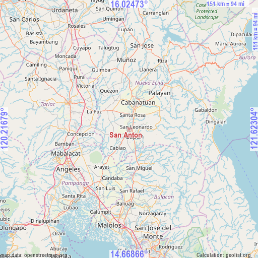
San Anton GPS coordinates[2]
15° 20' 52.08" North, 120° 55' 11.676" East
| Map corner | latitude | longitude |
|---|---|---|
| Upper-left | 16.02473°, | 120.21679° |
| Center: | 15.3478°, | 120.91991° |
| Lower-right: | 14.66866°, | 121.62304° |
| Map W x H: | 150.8×150.8 km | = 93.7×93.7mi |
| max Lat: | 20.78733° ⇑19.7% North |
| San Anton: | 15.3478° |
| min Lat: | ⇓80.3% South 4.65442° |
| min Long | San Anton | max Long |
| 117.04868° | 120.91991° | 126.58417° |
| W 21.3%⇐ | ⇒78.7% E |
Elevation
Elevation of San Anton is 26 m = 85 ft, and this is 61.9 m = 203 ft below average elevation for this country.
| Max E: |
2262 m = 7421 ft | 46.5% |
| Avg. | 87.9 m = 288 ft | |
| San Anton | 26 m = 85 ft | |
Min E: |
-2 m = -7 ft | 53.5% |
See also: Philippines elevation on elevation.city.
Geographical zone
San Anton is located in North Torrid zone (between Equator and Tropic of Cancer). Distance of this Northern Tropic circle is 899.4 km =558.9 mi to North.| Distance of | km | miles | from San Anton |
|---|---|---|---|
| North Pole | 8300.5 | 5157.7 | to North |
| Arctic Circle | 5694.7 | 3538.5 | to North |
| Tropic Cancer | 899.4 | 558.9 | to North |
| Equator | 1706.5 | 1060.4 | to South |


Nearby cities:
15 places around San Anton: (largest is in red/bold)
• Alua
4.9 km =3 mi,  214°
214°
• Calaba
7.2 km =4.5 mi,  222°
222°
• Gapan
5.3 km =3.3 mi,  147°
147°
• Jaen
2.3 km =1.4 mi,  181°
181°
• Lambakin
6.9 km =4.3 mi,  292°
292°
• Lawang Kupang
6.7 km =4.2 mi,  270°
270°
• Nieves
3.8 km =2.4 mi,  124°
124°
• Putlod
6.2 km =3.9 mi, 294°
• San Antonio
8.3 km =5.2 mi,  235°
235°
• San Leonardo
5 km =3.1 mi,  70°
70°
• San Mariano
5.6 km =3.5 mi, 237°
• Santa Cruz
8.4 km =5.2 mi, 238°
• Santo Cristo
6.5 km =4 mi, 209°
• Tabuating
5.4 km =3.4 mi,  24°
24°
• Tikiw
7.5 km =4.7 mi, 237°
Sources, notices
• [Note1] Compared only with cities in Philippines existing in our database
• [Src1] Map data: © OpenStreetMap contributors (CC-BY-SA)
• [Src2] Other city data from geonames.org with taken over terms of usage.
• [Src3] Geographical zone / Annual Mean Temperature by Robert A. Rohde @ Wikipedia
