Jaen geodata
Jaen (Central Luzon) is a seat of a third-order administrative division; located in Philippines in Asia/Manila (GMT+8) time zone. With population of 39,700 people, there are 217 cities with bigger population in this country. Compared to other cities in Philippines, 80.1% of cities are located further ↓South; 78.8% of cities are located further →East and 52.3% of cities have lower elevation than Jaen. Note1


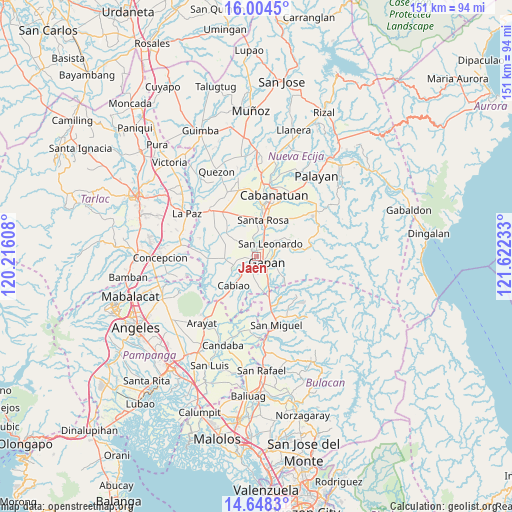
Jaen GPS coordinates[2]
15° 19' 39" North, 120° 55' 9.12" East
| Map corner | latitude | longitude |
|---|---|---|
| Upper-left | 16.0045°, | 120.21608° |
| Center: | 15.3275°, | 120.9192° |
| Lower-right: | 14.6483°, | 121.62233° |
| Map W x H: | 150.8×150.8 km | = 93.7×93.7mi |
| max Lat: | 20.78733° ⇑19.9% North |
| Jaen: | 15.3275° |
| min Lat: | ⇓80.1% South 4.65442° |
| min Long | Jaen | max Long |
| 117.04868° | 120.9192° | 126.58417° |
| W 21.2%⇐ | ⇒78.8% E |
Elevation
Elevation of Jaen is 25 m = 82 ft, and this is 62.9 m = 206 ft below average elevation for this country.
| Max E: |
2262 m = 7421 ft | 47.7% |
| Avg. | 87.9 m = 288 ft | |
| Jaen | 25 m = 82 ft | |
Min E: |
-2 m = -7 ft | 52.3% |
See also: Philippines elevation on elevation.city.
Geographical zone
Jaen is located in North Torrid zone (between Equator and Tropic of Cancer). Distance of this Northern Tropic circle is 901.7 km =560.3 mi to North.| Distance of | km | miles | from Jaen |
|---|---|---|---|
| North Pole | 8302.8 | 5159.1 | to North |
| Arctic Circle | 5696.9 | 3539.9 | to North |
| Tropic Cancer | 901.7 | 560.3 | to North |
| Equator | 1704.3 | 1059 | to South |


Nearby cities:
15 places around Jaen: (largest is in red/bold)
• Alua
3.2 km =2 mi,  236°
236°
• Calaba
5.7 km =3.5 mi, 238°
• Gapan
3.7 km =2.3 mi,  127°
127°
• Lawang Kupang
7 km =4.3 mi,  289°
289°
• Nieves
3.2 km =2 mi,  88°
88°
• Putlod
7.3 km =4.5 mi,  310°
310°
• San Anton
2.3 km =1.4 mi,  1°
1°
• San Antonio
7.2 km =4.5 mi,  250°
250°
• San Leonardo
6.2 km =3.9 mi,  50°
50°
• San Mariano
4.7 km =2.9 mi,  260°
260°
• Santa Cruz
7.4 km =4.6 mi, 253°
• Santo Cristo
4.6 km =2.9 mi,  222°
222°
• Tabon
6.3 km =3.9 mi,  186°
186°
• Tabuating
7.5 km =4.7 mi,  17°
17°
• Tikiw
6.5 km =4 mi, 254°
Sources, notices
• [Note1] Compared only with cities in Philippines existing in our database
• [Src1] Map data: © OpenStreetMap contributors (CC-BY-SA)
• [Src2] Other city data from geonames.org with taken over terms of usage.
• [Src3] Geographical zone / Annual Mean Temperature by Robert A. Rohde @ Wikipedia
