Alegria geodata
Alegria (Eastern Visayas) is a populated place; located in Philippines in Asia/Manila (GMT+8) time zone. With population of 5,811 people, there are 1082 cities with bigger population in this country. Compared to other cities in Philippines, 54.1% of cities are located further ↓South; 76.1% of cities are located further ←West and 89.7% of cities have higher elevation than Alegria. Note1
Administrative division(s):
- Level 1: Eastern Visayas
- Level 2: Province of Northern Samar
- Level 3: San Isidro


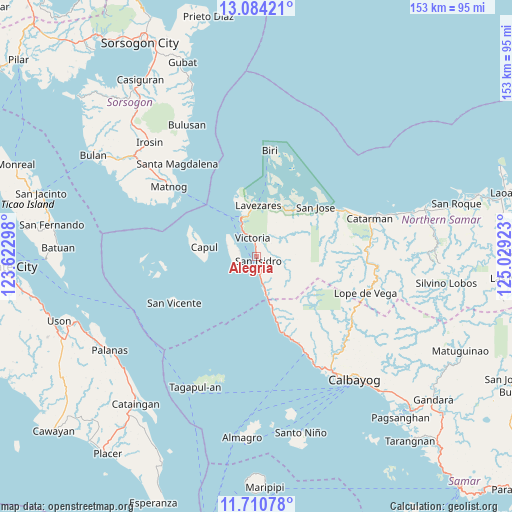
Alegria GPS coordinates[2]
12° 23' 54.24" North, 124° 19' 33.96" East
| Map corner | latitude | longitude |
|---|---|---|
| Upper-left | 13.08421°, | 123.62298° |
| Center: | 12.3984°, | 124.3261° |
| Lower-right: | 11.71078°, | 125.02923° |
| Map W x H: | 152.7×152.7 km | = 94.9×94.9mi |
| max Lat: | 20.78733° ⇑45.9% North |
| Alegria: | 12.3984° |
| min Lat: | ⇓54.1% South 4.65442° |
| min Long | Alegria | max Long |
| 117.04868° | 124.3261° | 126.58417° |
| W 76.1%⇐ | ⇒23.9% E |
Elevation
Elevation of Alegria is 7 m = 23 ft, and this is 80.9 m = 265 ft below average elevation for this country.
| Max E: |
2262 m = 7421 ft | 89.7% |
| Avg. | 87.9 m = 288 ft | |
| Alegria | 7 m = 23 ft | |
Min E: |
-2 m = -7 ft | 10.3% |
See also: Philippines elevation on elevation.city.
Geographical zone
Alegria is located in North Torrid zone (between Equator and Tropic of Cancer). Distance of this Northern Tropic circle is 1227.3 km =762.6 mi to North.| Distance of | km | miles | from Alegria |
|---|---|---|---|
| North Pole | 8628.5 | 5361.5 | to North |
| Arctic Circle | 6022.6 | 3742.3 | to North |
| Tropic Cancer | 1227.3 | 762.6 | to North |
| Equator | 1378.6 | 856.6 | to South |


Nearby cities:
15 places around Alegria: (largest is in red/bold)
• Allen
12.2 km =7.6 mi,  338°
338°
• Capul
16 km =9.9 mi,  280°
280°
• Erenas
2.9 km =1.8 mi,  355°
355°
• Jubasan
10.5 km =6.5 mi, 336°
• Lavezares
15 km =9.3 mi,  1°
1°
• Malaga
18.7 km =11.6 mi,  163°
163°
• Palanit
8.8 km =5.5 mi,  167°
167°
• Piña
24.5 km =15.2 mi, 160°
• Rosario
17.5 km =10.9 mi,  37°
37°
• San Antonio
5.4 km =3.4 mi,  287°
287°
• San Isidro
1.3 km =0.8 mi,  153°
153°
• San Joaquin
28.1 km =17.5 mi, 156°
• San Jose
22.8 km =14.2 mi,  50°
50°
• Victoria
5.7 km =3.5 mi, 343°
• Viriato
12.4 km =7.7 mi, 166°
Sources, notices
• [Note1] Compared only with cities in Philippines existing in our database
• [Src1] Map data: © OpenStreetMap contributors (CC-BY-SA)
• [Src2] Other city data from geonames.org with taken over terms of usage.
• [Src3] Geographical zone / Annual Mean Temperature by Robert A. Rohde @ Wikipedia
