San Antonio geodata
San Antonio (Eastern Visayas) is a seat of a third-order administrative division; located in Philippines in Asia/Manila (GMT+8) time zone. In our database, there are 4166 cities with bigger population. Compared to other cities in Philippines, 54.3% of cities are located further ↓South; 75% of cities are located further ←West and 95.5% of cities have higher elevation than San Antonio. Note1
Administrative division(s):
- Level 1: Eastern Visayas
- Level 2: Province of Northern Samar
- Level 3: San Antonio


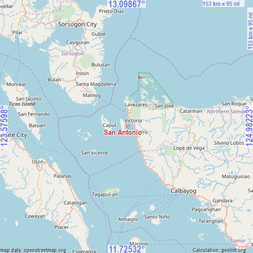
San Antonio GPS coordinates[2]
12° 24' 46.44" North, 124° 16' 44.76" East
| Map corner | latitude | longitude |
|---|---|---|
| Upper-left | 13.09867°, | 123.57598° |
| Center: | 12.4129°, | 124.2791° |
| Lower-right: | 11.72532°, | 124.98223° |
| Map W x H: | 152.7×152.7 km | = 94.9×94.9mi |
| max Lat: | 20.78733° ⇑45.7% North |
| San Antonio: | 12.4129° |
| min Lat: | ⇓54.3% South 4.65442° |
| min Long | San Antonio | max Long |
| 117.04868° | 124.2791° | 126.58417° |
| W 75%⇐ | ⇒25% E |
Elevation
Elevation of San Antonio is 5 m = 16 ft, and this is 82.9 m = 272 ft below average elevation for this country.
| Max E: |
2262 m = 7421 ft | 95.5% |
| Avg. | 87.9 m = 288 ft | |
| San Antonio | 5 m = 16 ft | |
Min E: |
-2 m = -7 ft | 4.5% |
See also: Philippines elevation on elevation.city.
Geographical zone
San Antonio is located in North Torrid zone (between Equator and Tropic of Cancer). Distance of this Northern Tropic circle is 1225.7 km =761.6 mi to North.| Distance of | km | miles | from San Antonio |
|---|---|---|---|
| North Pole | 8626.9 | 5360.5 | to North |
| Arctic Circle | 6021 | 3741.3 | to North |
| Tropic Cancer | 1225.7 | 761.6 | to North |
| Equator | 1380.2 | 857.6 | to South |


Nearby cities:
15 places around San Antonio: (largest is in red/bold)
• Alegria
5.4 km =3.4 mi,  107°
107°
• Allen
9.8 km =6.1 mi,  3°
3°
• Capul
10.7 km =6.6 mi,  276°
276°
• Erenas
5 km =3.1 mi,  75°
75°
• Jubasan
8 km =5 mi,  6°
6°
• Lavezares
14.5 km =9 mi,  22°
22°
• Malaga
22.2 km =13.8 mi,  151°
151°
• Palanit
12.3 km =7.6 mi, 145°
• Piña
28 km =17.4 mi, 151°
• Rosario
20 km =12.4 mi,  52°
52°
• San Isidro
6.3 km =3.9 mi,  115°
115°
• San Jose
26.1 km =16.2 mi,  60°
60°
• San Vicente
25 km =15.5 mi,  230°
230°
• Victoria
5.2 km =3.2 mi,  42°
42°
• Viriato
15.8 km =9.8 mi, 149°
Sources, notices
• [Note1] Compared only with cities in Philippines existing in our database
• [Src1] Map data: © OpenStreetMap contributors (CC-BY-SA)
• [Src2] Other city data from geonames.org with taken over terms of usage.
• [Src3] Geographical zone / Annual Mean Temperature by Robert A. Rohde @ Wikipedia
