Capul geodata
Capul (Eastern Visayas) is a seat of a third-order administrative division; located in Philippines in Asia/Manila (GMT+8) time zone. With population of 4,756 people, there are 1393 cities with bigger population in this country. Compared to other cities in Philippines, 54.3% of cities are located further ↓South; 73.8% of cities are located further ←West and 92.7% of cities have higher elevation than Capul. Note1
Administrative division(s):
- Level 1: Eastern Visayas
- Level 2: Province of Northern Samar
- Level 3: Capul


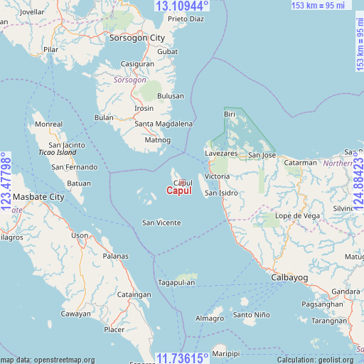
Capul GPS coordinates[2]
12° 25' 25.32" North, 124° 10' 51.96" East
| Map corner | latitude | longitude |
|---|---|---|
| Upper-left | 13.10944°, | 123.47798° |
| Center: | 12.4237°, | 124.1811° |
| Lower-right: | 11.73615°, | 124.88423° |
| Map W x H: | 152.7×152.7 km | = 94.9×94.9mi |
| max Lat: | 20.78733° ⇑45.7% North |
| Capul: | 12.4237° |
| min Lat: | ⇓54.3% South 4.65442° |
| min Long | Capul | max Long |
| 117.04868° | 124.1811° | 126.58417° |
| W 73.8%⇐ | ⇒26.2% E |
Elevation
Elevation of Capul is 6 m = 20 ft, and this is 81.9 m = 269 ft below average elevation for this country.
| Max E: |
2262 m = 7421 ft | 92.7% |
| Avg. | 87.9 m = 288 ft | |
| Capul | 6 m = 20 ft | |
Min E: |
-2 m = -7 ft | 7.3% |
See also: Philippines elevation on elevation.city.
Geographical zone
Capul is located in North Torrid zone (between Equator and Tropic of Cancer). Distance of this Northern Tropic circle is 1224.5 km =760.9 mi to North.| Distance of | km | miles | from Capul |
|---|---|---|---|
| North Pole | 8625.7 | 5359.8 | to North |
| Arctic Circle | 6019.8 | 3740.5 | to North |
| Tropic Cancer | 1224.5 | 760.9 | to North |
| Equator | 1381.4 | 858.4 | to South |


Nearby cities:
15 places around Capul: (largest is in red/bold)
• Alegria
16 km =9.9 mi,  100°
100°
• Allen
14.1 km =8.8 mi,  52°
52°
• Erenas
15.5 km =9.6 mi,  89°
89°
• Jubasan
13.4 km =8.3 mi,  59°
59°
• Lavezares
20.3 km =12.6 mi, 53°
• Malaga
29.6 km =18.4 mi,  134°
134°
• Matnog
20.9 km =13 mi,  330°
330°
• Palanit
21 km =13 mi,  122°
122°
• Rosario
28.7 km =17.8 mi,  67°
67°
• San Antonio
10.7 km =6.6 mi, 96°
• San Isidro
16.8 km =10.4 mi, 103°
• San Vicente
19.1 km =11.9 mi,  207°
207°
• Santa Magdalena
26.1 km =16.2 mi,  342°
342°
• Victoria
14.4 km =8.9 mi,  79°
79°
• Viriato
23.9 km =14.9 mi, 128°
Sources, notices
• [Note1] Compared only with cities in Philippines existing in our database
• [Src1] Map data: © OpenStreetMap contributors (CC-BY-SA)
• [Src2] Other city data from geonames.org with taken over terms of usage.
• [Src3] Geographical zone / Annual Mean Temperature by Robert A. Rohde @ Wikipedia
