San Pablo geodata
San Pablo (Calabarzon) is a populated place; located in Philippines in Asia/Manila (GMT+8) time zone. With population of 207,577 people, there are 52 cities with bigger population in this country. Compared to other cities in Philippines, 70.1% of cities are located further ↓South; 69.8% of cities are located further →East and 82.9% of cities have lower elevation than San Pablo. Note1


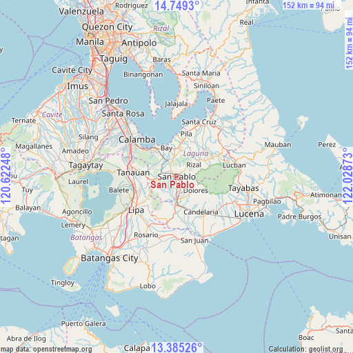
San Pablo GPS coordinates[2]
14° 4' 5.88" North, 121° 19' 32.16" East
| Map corner | latitude | longitude |
|---|---|---|
| Upper-left | 14.7493°, | 120.62248° |
| Center: | 14.0683°, | 121.3256° |
| Lower-right: | 13.38526°, | 122.02873° |
| Map W x H: | 151.7×151.7 km | = 94.3×94.3mi |
| max Lat: | 20.78733° ⇑29.9% North |
| San Pablo: | 14.0683° |
| min Lat: | ⇓70.1% South 4.65442° |
| min Long | San Pablo | max Long |
| 117.04868° | 121.3256° | 126.58417° |
| W 30.2%⇐ | ⇒69.8% E |
Elevation
Elevation of San Pablo is 115 m = 377 ft, and this is 27.1 m = 89 ft above average elevation for this country.
| Max E: |
2262 m = 7421 ft | 17.1% |
| San Pablo | 115 m 377 ft | |
| Avg. | 87.9 m = 288 ft | |
Min E: |
-2 m = -7 ft | 82.9% |
See also: San Pablo elevation on elevation.city.
Geographical zone
San Pablo is located in North Torrid zone (between Equator and Tropic of Cancer). Distance of this Northern Tropic circle is 1041.7 km =647.3 mi to North.| Distance of | km | miles | from San Pablo |
|---|---|---|---|
| North Pole | 8442.8 | 5246.1 | to North |
| Arctic Circle | 5836.9 | 3626.9 | to North |
| Tropic Cancer | 1041.7 | 647.3 | to North |
| Equator | 1564.2 | 971.9 | to South |


Nearby cities:
15 places around San Pablo: (largest is in red/bold)
• Alaminos
8.5 km =5.3 mi,  266°
266°
• Bautista
9.7 km =6 mi,  212°
212°
• Bungoy
9 km =5.6 mi,  151°
151°
• Calauan
9.1 km =5.7 mi,  352°
352°
• Dagatan
9.2 km =5.7 mi,  143°
143°
• Dolores
10.4 km =6.5 mi,  119°
119°
• Lalig
9.5 km =5.9 mi,  179°
179°
• Masaya
10.4 km =6.5 mi,  333°
333°
• Rizal
8.6 km =5.3 mi,  58°
58°
• San Gregorio
7.9 km =4.9 mi,  237°
237°
• Santa Catalina
6.1 km =3.8 mi,  16°
16°
• Santa Cruz
6.3 km =3.9 mi, 147°
• Santa Cruz
7.1 km =4.4 mi,  319°
319°
• Santiago
7.3 km =4.5 mi,  223°
223°
• Santisimo Rosario
8.2 km =5.1 mi,  192°
192°
Sources, notices
• [Note1] Compared only with cities in Philippines existing in our database
• [Src1] Map data: © OpenStreetMap contributors (CC-BY-SA)
• [Src2] Other city data from geonames.org with taken over terms of usage.
• [Src3] Geographical zone / Annual Mean Temperature by Robert A. Rohde @ Wikipedia
