Agoo geodata
Agoo (Ilocos) is a populated place; located in Philippines in Asia/Manila (GMT+8) time zone. With population of 28,972 people, there are 285 cities with bigger population in this country. Compared to other cities in Philippines, 88.5% of cities are located further ↓South; 96.5% of cities are located further →East and 55.6% of cities have lower elevation than Agoo. Note1


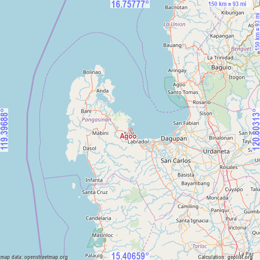
Agoo GPS coordinates[2]
16° 4' 59.988" North, 120° 6' 0" East
| Map corner | latitude | longitude |
|---|---|---|
| Upper-left | 16.75777°, | 119.39688° |
| Center: | 16.08333°, | 120.1° |
| Lower-right: | 15.40659°, | 120.80313° |
| Map W x H: | 150.2×150.2 km | = 93.3×93.3mi |
| max Lat: | 20.78733° ⇑11.5% North |
| Agoo: | 16.08333° |
| min Lat: | ⇓88.5% South 4.65442° |
| min Long | Agoo | max Long |
| 117.04868° | 120.1° | 126.58417° |
| W 3.5%⇐ | ⇒96.5% E |
Elevation
Elevation of Agoo is 28 m = 92 ft, and this is 59.9 m = 197 ft below average elevation for this country.
| Max E: |
2262 m = 7421 ft | 44.4% |
| Avg. | 87.9 m = 288 ft | |
| Agoo | 28 m = 92 ft | |
Min E: |
-2 m = -7 ft | 55.6% |
See also: Philippines elevation on elevation.city.
Geographical zone
Agoo is located in North Torrid zone (between Equator and Tropic of Cancer). Distance of this Northern Tropic circle is 817.6 km =508 mi to North.| Distance of | km | miles | from Agoo |
|---|---|---|---|
| North Pole | 8218.8 | 5106.9 | to North |
| Arctic Circle | 5612.9 | 3487.7 | to North |
| Tropic Cancer | 817.6 | 508 | to North |
| Equator | 1788.3 | 1111.2 | to South |


Nearby cities:
15 places around Agoo: (largest is in red/bold)
• Alaminos
15.1 km =9.4 mi,  302°
302°
• Bolo
12 km =7.5 mi,  144°
144°
• Boñgalon
11.2 km =7 mi,  145°
145°
• Bued
13.8 km =8.6 mi,  308°
308°
• Domalanoan
14.9 km =9.3 mi,  126°
126°
• Dulig
11.6 km =7.2 mi, 140°
• Labrador
7.7 km =4.8 mi, 142°
• Magtaking
14.1 km =8.8 mi, 140°
• Paitan Este
7.3 km =4.5 mi,  271°
271°
• Pangascasan
4 km =2.5 mi,  339°
339°
• Sual
1.9 km =1.2 mi,  198°
198°
• Tagudin
15.6 km =9.7 mi, 268°
• Telbang
10.8 km =6.7 mi, 337°
• Tobuan
3.3 km =2.1 mi,  160°
160°
• Uyong
4.3 km =2.7 mi, 149°
Sources, notices
• [Note1] Compared only with cities in Philippines existing in our database
• [Src1] Map data: © OpenStreetMap contributors (CC-BY-SA)
• [Src2] Other city data from geonames.org with taken over terms of usage.
• [Src3] Geographical zone / Annual Mean Temperature by Robert A. Rohde @ Wikipedia
