Paitan Este geodata
Paitan Este (Ilocos) is a populated place; located in Philippines in Asia/Manila (GMT+8) time zone. With population of 2,826 people, there are 2748 cities with bigger population in this country. Compared to other cities in Philippines, 88.5% of cities are located further ↓South; 96.9% of cities are located further →East and 62.2% of cities have lower elevation than Paitan Este. Note1


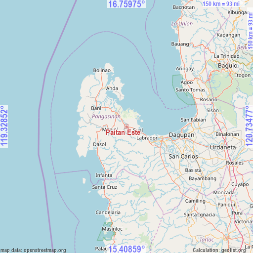
Paitan Este GPS coordinates[2]
16° 5' 7.152" North, 120° 1' 53.904" East
| Map corner | latitude | longitude |
|---|---|---|
| Upper-left | 16.75975°, | 119.32852° |
| Center: | 16.08532°, | 120.03164° |
| Lower-right: | 15.40859°, | 120.73477° |
| Map W x H: | 150.2×150.2 km | = 93.3×93.3mi |
| max Lat: | 20.78733° ⇑11.5% North |
| Paitan Este: | 16.08532° |
| min Lat: | ⇓88.5% South 4.65442° |
| min Long | Paitan Este | max Long |
| 117.04868° | 120.03164° | 126.58417° |
| W 3.1%⇐ | ⇒96.9% E |
Elevation
Elevation of Paitan Este is 37 m = 121 ft, and this is 50.9 m = 167 ft below average elevation for this country.
| Max E: |
2262 m = 7421 ft | 37.8% |
| Avg. | 87.9 m = 288 ft | |
| Paitan Este | 37 m = 121 ft | |
Min E: |
-2 m = -7 ft | 62.2% |
See also: Philippines elevation on elevation.city.
Geographical zone
Paitan Este is located in North Torrid zone (between Equator and Tropic of Cancer). Distance of this Northern Tropic circle is 817.4 km =507.9 mi to North.| Distance of | km | miles | from Paitan Este |
|---|---|---|---|
| North Pole | 8218.5 | 5106.7 | to North |
| Arctic Circle | 5612.7 | 3487.6 | to North |
| Tropic Cancer | 817.4 | 507.9 | to North |
| Equator | 1788.5 | 1111.3 | to South |


Nearby cities:
15 places around Paitan Este: (largest is in red/bold)
• Agoo
7.3 km =4.5 mi,  91°
91°
• Alaminos
9.5 km =5.9 mi,  325°
325°
• Boñgalon
16.6 km =10.3 mi,  124°
124°
• Bued
9.1 km =5.7 mi,  337°
337°
• Caabiangan
11.4 km =7.1 mi,  271°
271°
• Labrador
13.6 km =8.5 mi, 117°
• Lucap
12.1 km =7.5 mi, 344°
• Mabini
10 km =6.2 mi,  260°
260°
• Pangascasan
6.8 km =4.2 mi,  59°
59°
• Polo
15.2 km =9.4 mi,  324°
324°
• Sual
7 km =4.3 mi,  107°
107°
• Tagudin
8.3 km =5.2 mi, 266°
• Telbang
10.2 km =6.3 mi,  17°
17°
• Tobuan
9 km =5.6 mi, 111°
• Uyong
10.3 km =6.4 mi, 112°
Sources, notices
• [Note1] Compared only with cities in Philippines existing in our database
• [Src1] Map data: © OpenStreetMap contributors (CC-BY-SA)
• [Src2] Other city data from geonames.org with taken over terms of usage.
• [Src3] Geographical zone / Annual Mean Temperature by Robert A. Rohde @ Wikipedia
