Tunggol geodata
Tunggol (Autonomous Region in Muslim Mindanao) is a populated place; located in Philippines in Asia/Manila (GMT+8) time zone. With population of 3,013 people, there are 2515 cities with bigger population in this country. Compared to other cities in Philippines, 99% of cities are located further ↑North; 72.4% of cities are located further →East and 95.5% of cities have higher elevation than Tunggol. Note1


Tunggol GPS coordinates[2]
5° 50' 40.488" North, 121° 9' 15.696" East
| Map corner | latitude | longitude |
|---|---|---|
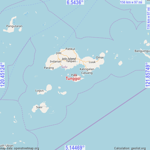
| Upper-left | 6.5436°, | 120.45124° |
| Center: | 5.84458°, | 121.15436° |
| Lower-right: | 5.14469°, | 121.85749° |
| Map W x H: | 155.5×155.5 km | = 96.6×96.6mi |
| max Lat: | 20.78733° ⇑99% North |
| Tunggol: | 5.84458° |
| min Lat: | ⇓1% South 4.65442° |
| min Long | Tunggol | max Long |
| 117.04868° | 121.15436° | 126.58417° |
| W 27.6%⇐ | ⇒72.4% E |
Elevation
Elevation of Tunggol is 5 m = 16 ft, and this is 82.9 m = 272 ft below average elevation for this country.
| Max E: |
2262 m = 7421 ft | 95.5% |
| Avg. | 87.9 m = 288 ft | |
| Tunggol | 5 m = 16 ft | |
Min E: |
-2 m = -7 ft | 4.5% |
See also: Philippines elevation on elevation.city.
Geographical zone
Tunggol is located in North Torrid zone (between Equator and Tropic of Cancer). Distance of Equator is 649.9 km =403.8 mi to South.| Distance of | km | miles | from Tunggol |
|---|---|---|---|
| North Pole | 9357.2 | 5814.3 | to North |
| Arctic Circle | 6751.3 | 4195.1 | to North |
| Tropic Cancer | 1956.1 | 1215.5 | to North |
| Equator | 649.9 | 403.8 | to South |


Nearby cities:
15 places around Tunggol: (largest is in red/bold)
• Binuang
16.3 km =10.1 mi,  320°
320°
• Kanlagay
15.6 km =9.7 mi,  77°
77°
• Karungdong
12.8 km =8 mi,  69°
69°
• Kulay-Kulay
14.1 km =8.8 mi,  37°
37°
• Mahala
8.3 km =5.2 mi,  343°
343°
• Maimbung
17.4 km =10.8 mi,  304°
304°
• Marsada
11 km =6.8 mi,  331°
331°
• Mauboh
17.5 km =10.9 mi, 337°
• New Panamao
12.8 km =8 mi,  23°
23°
• Pananaw
16.6 km =10.3 mi, 23°
• Pandakan
16.1 km =10 mi,  4°
4°
• Pitogo
18.1 km =11.2 mi, 74°
• Punay
13.9 km =8.6 mi, 20°
• Talipao
15.3 km =9.5 mi, 343°
• Talipaw
9.8 km =6.1 mi, 317°
Sources, notices
• [Note1] Compared only with cities in Philippines existing in our database
• [Src1] Map data: © OpenStreetMap contributors (CC-BY-SA)
• [Src2] Other city data from geonames.org with taken over terms of usage.
• [Src3] Geographical zone / Annual Mean Temperature by Robert A. Rohde @ Wikipedia
