East Migpulao geodata
East Migpulao (Zamboanga Peninsula) is a populated place; located in Philippines in Asia/Manila (GMT+8) time zone. With population of 2,689 people, there are 2966 cities with bigger population in this country. Compared to other cities in Philippines, 85.7% of cities are located further ↑North; 59.5% of cities are located further ←West and 92.7% of cities have higher elevation than East Migpulao. Note1
Administrative division(s):
- Level 1: Zamboanga Peninsula
- Level 2: Province of Zamboanga del Sur
- Level 3: Dinas


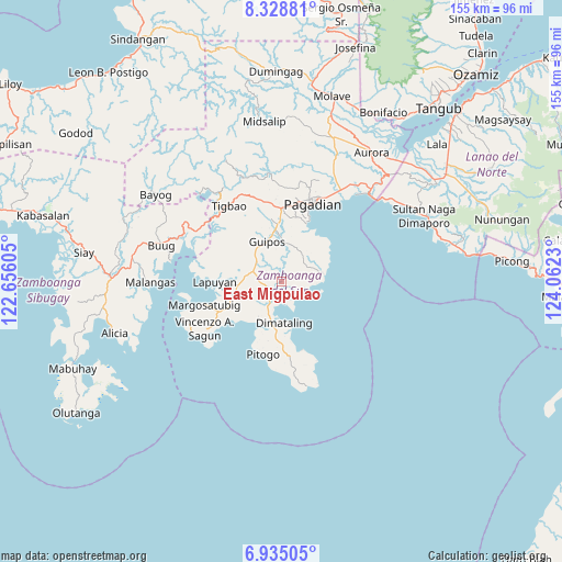
East Migpulao GPS coordinates[2]
7° 37' 57" North, 123° 21' 33.012" East
| Map corner | latitude | longitude |
|---|---|---|
| Upper-left | 8.32881°, | 122.65605° |
| Center: | 7.6325°, | 123.35917° |
| Lower-right: | 6.93505°, | 124.0623° |
| Map W x H: | 155×155 km | = 96.3×96.3mi |
| max Lat: | 20.78733° ⇑85.7% North |
| East Migpulao: | 7.6325° |
| min Lat: | ⇓14.3% South 4.65442° |
| min Long | East Migpulao | max Long |
| 117.04868° | 123.35917° | 126.58417° |
| W 59.5%⇐ | ⇒40.5% E |
Elevation
Elevation of East Migpulao is 6 m = 20 ft, and this is 81.9 m = 269 ft below average elevation for this country.
| Max E: |
2262 m = 7421 ft | 92.7% |
| Avg. | 87.9 m = 288 ft | |
| East Migpulao | 6 m = 20 ft | |
Min E: |
-2 m = -7 ft | 7.3% |
See also: Philippines elevation on elevation.city.
Geographical zone
East Migpulao is located in North Torrid zone (between Equator and Tropic of Cancer). Distance of Equator is 848.7 km =527.4 mi to South.| Distance of | km | miles | from East Migpulao |
|---|---|---|---|
| North Pole | 9158.4 | 5690.8 | to North |
| Arctic Circle | 6552.5 | 4071.5 | to North |
| Tropic Cancer | 1757.3 | 1091.9 | to North |
| Equator | 848.7 | 527.4 | to South |


Nearby cities:
15 places around East Migpulao: (largest is in red/bold)
• Binuatan
2.8 km =1.7 mi,  216°
216°
• Dimataling
11 km =6.8 mi,  171°
171°
• Guiniculalay
4.4 km =2.7 mi,  53°
53°
• Guipos
10.2 km =6.3 mi,  336°
336°
• Kalian
14.7 km =9.1 mi,  252°
252°
• Lapuyan
18.2 km =11.3 mi,  271°
271°
• Legrada
6 km =3.7 mi, 270°
• Lumbog
19.3 km =12 mi,  244°
244°
• Pitogo
20.5 km =12.7 mi,  194°
194°
• Robonkon
15 km =9.3 mi,  25°
25°
• Sagacad
6.3 km =3.9 mi, 341°
• San Miguel
10.3 km =6.4 mi,  279°
279°
• San Pablo
11.5 km =7.1 mi,  76°
76°
• Tabina
19.2 km =11.9 mi,  163°
163°
• Tiguha
18.1 km =11.2 mi,  296°
296°
Sources, notices
• [Note1] Compared only with cities in Philippines existing in our database
• [Src1] Map data: © OpenStreetMap contributors (CC-BY-SA)
• [Src2] Other city data from geonames.org with taken over terms of usage.
• [Src3] Geographical zone / Annual Mean Temperature by Robert A. Rohde @ Wikipedia
