Tando Bago geodata
Tando Bago (Sindh) is a populated place; located in Pakistan in Asia/Karachi (GMT+5) time zone. With population of 14,095 people, there are 325 cities with bigger population in this country. Compared to other cities in Pakistan, 97.3% of cities are located further ↑North; 70.2% of cities are located further →East and 93.9% of cities have higher elevation than Tando Bago. Note1


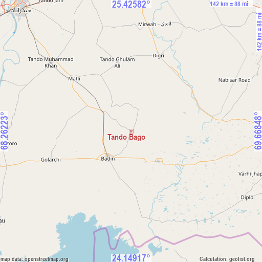
Tando Bago GPS coordinates[2]
24° 47' 20.904" North, 68° 57' 55.26" East
| Map corner | latitude | longitude |
|---|---|---|
| Upper-left | 25.42582°, | 68.26223° |
| Center: | 24.78914°, | 68.96535° |
| Lower-right: | 24.14917°, | 69.66848° |
| Map W x H: | 142×142 km | = 88.2×88.2mi |
| max Lat: | 36.32162° ⇑97.3% North |
| Tando Bago: | 24.78914° |
| min Lat: | ⇓2.7% South 24.14422° |
| min Long | Tando Bago | max Long |
| 61.74573° | 68.96535° | 75.63372° |
| W 29.8%⇐ | ⇒70.2% E |
Elevation
Elevation of Tando Bago is 18 m = 59 ft, and this is 327 m = 1073 ft below average elevation for this country.
| Max E: |
2732 m = 8963 ft | 93.9% |
| Avg. | 345 m = 1132 ft | |
| Tando Bago | 18 m = 59 ft | |
Min E: |
3 m = 10 ft | 6.1% |
See also: Pakistan elevation on elevation.city.
Geographical zone
Tando Bago is located in North temperate zone (between Tropic of Cancer and the Arctic Circle). Distance of this Northern Tropic circle is 150.4 km =93.5 mi to South.| Distance of | km | miles | from Tando Bago |
|---|---|---|---|
| North Pole | 7250.8 | 4505.4 | to North |
| Arctic Circle | 4644.9 | 2886.2 | to North |
| Tropic Cancer | 150.4 | 93.5 | to South |
| Equator | 2756.3 | 1712.7 | to South |


Nearby cities:
15 places around Tando Bago: (largest is in red/bold)
• Badin
19.7 km =12.2 mi,  221°
221°
• Bulri
64.4 km =40 mi,  277°
277°
• Chamber
58.2 km =36.2 mi,  344°
344°
• Digri
43.4 km =27 mi,  19°
19°
• Diplo
71.8 km =44.6 mi,  119°
119°
• Kadhan
34.4 km =21.4 mi,  176°
176°
• Kario Ghanwar
36.5 km =22.7 mi,  273°
273°
• Matli
42.1 km =26.2 mi,  312°
312°
• Mirpur Bhtoro
71.5 km =44.4 mi,  264°
264°
• Mirwah Gorchani
58.5 km =36.4 mi,  8°
8°
• Naukot
44.7 km =27.8 mi,  80°
80°
• Rajo Khanani
24.4 km =15.2 mi,  332°
332°
• Samaro
69.9 km =43.4 mi,  38°
38°
• Talhar
18.6 km =11.6 mi,  304°
304°
• Tando Muhammad Khan
57 km =35.4 mi, 310°
Sources, notices
• [Note1] Compared only with cities in Pakistan existing in our database
• [Src1] Map data: © OpenStreetMap contributors (CC-BY-SA)
• [Src2] Other city data from geonames.org with taken over terms of usage.
• [Src3] Geographical zone / Annual Mean Temperature by Robert A. Rohde @ Wikipedia
