Michałowice geodata
Michałowice (Lesser Poland) is a seat of a third-order administrative division; located in Poland in Europe/Warsaw (GMT+2) time zone. With population of 1,600 people, there are 1751 cities with bigger population in this country. Compared to other cities in Poland, 75.7% of cities are located further ↑North; 58.1% of cities are located further ←West and 75.1% of cities have lower elevation than Michałowice. Note1


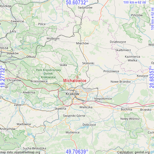
Michałowice GPS coordinates[2]
50° 9' 32.328" North, 19° 58' 49.584" East
| Map corner | latitude | longitude |
|---|---|---|
| Upper-left | 50.60732°, | 19.27732° |
| Center: | 50.15898°, | 19.98044° |
| Lower-right: | 49.70639°, | 20.68357° |
| Map W x H: | 100.2×100.2 km | = 62.3×62.3mi |
| max Lat: | 54.83135° ⇑75.7% North |
| Michałowice: | 50.15898° |
| min Lat: | ⇓24.3% South 49.21328° |
| min Long | Michałowice | max Long |
| 14.20249° | 19.98044° | 24.03723° |
| W 58.1%⇐ | ⇒41.9% E |
Elevation
Elevation of Michałowice is 247 m = 810 ft, and this is 55.6 m = 182 ft above average elevation for this country.
| Max E: |
974 m = 3196 ft | 24.9% |
| Michałowice | 247 m 810 ft | |
| Avg. | 191.4 m = 628 ft | |
Min E: |
-3 m = -10 ft | 75.1% |
See also: Poland elevation on elevation.city.
Geographical zone
Michałowice is located in North temperate zone (between Tropic of Cancer and the Arctic Circle). Distance of this North polar circle is 1824 km =1133.4 mi to North.| Distance of | km | miles | from Michałowice |
|---|---|---|---|
| North Pole | 4429.9 | 2752.6 | to North |
| Arctic Circle | 1824 | 1133.4 | to North |
| Tropic Cancer | 2971.2 | 1846.2 | to South |
| Equator | 5577.2 | 3465.5 | to South |


Nearby cities:
15 places around Michałowice: (largest is in red/bold)
• Baranówka
8.9 km =5.5 mi,  100°
100°
• Dojazdów
10.3 km =6.4 mi,  113°
113°
• Giebułtów
7.4 km =4.6 mi,  258°
258°
• Iwanowice
7.6 km =4.7 mi,  349°
349°
• Kocmyrzów
11.3 km =7 mi, 106°
• Luborzyca
9.9 km =6.2 mi, 105°
• Masłomiąca
1.5 km =0.9 mi,  79°
79°
• Miłocice
9.4 km =5.8 mi,  28°
28°
• Modlnica
8.9 km =5.5 mi,  248°
248°
• Modlniczka
10 km =6.2 mi,  242°
242°
• Niedźwiedź
10.8 km =6.7 mi,  48°
48°
• Sieciechowice
9.5 km =5.9 mi,  356°
356°
• Tomaszowice
9.9 km =6.2 mi, 254°
• Wielka Wieś
9.7 km =6 mi,  268°
268°
• Zielonki
6 km =3.7 mi,  224°
224°
Sources, notices
• [Note1] Compared only with cities in Poland existing in our database
• [Src1] Map data: © OpenStreetMap contributors (CC-BY-SA)
• [Src2] Other city data from geonames.org with taken over terms of usage.
• [Src3] Geographical zone / Annual Mean Temperature by Robert A. Rohde @ Wikipedia
