Zabrzeg geodata
Zabrzeg (Silesia) is a populated place; located in Poland in Europe/Warsaw (GMT+2) time zone. With population of 3,090 people, there are 1025 cities with bigger population in this country. Compared to other cities in Poland, 86.9% of cities are located further ↑North; 61% of cities are located further →East and 74.8% of cities have lower elevation than Zabrzeg. Note1


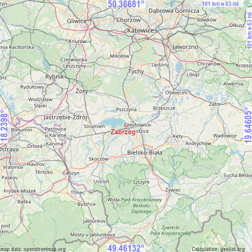
Zabrzeg GPS coordinates[2]
49° 54' 58.284" North, 18° 56' 34.512" East
| Map corner | latitude | longitude |
|---|---|---|
| Upper-left | 50.36681°, | 18.2398° |
| Center: | 49.91619°, | 18.94292° |
| Lower-right: | 49.46132°, | 19.64605° |
| Map W x H: | 100.7×100.7 km | = 62.6×62.6mi |
| max Lat: | 54.83135° ⇑86.9% North |
| Zabrzeg: | 49.91619° |
| min Lat: | ⇓13.1% South 49.21328° |
| min Long | Zabrzeg | max Long |
| 14.20249° | 18.94292° | 24.03723° |
| W 39%⇐ | ⇒61% E |
Elevation
Elevation of Zabrzeg is 246 m = 807 ft, and this is 54.6 m = 179 ft above average elevation for this country.
| Max E: |
974 m = 3196 ft | 25.2% |
| Zabrzeg | 246 m 807 ft | |
| Avg. | 191.4 m = 628 ft | |
Min E: |
-3 m = -10 ft | 74.8% |
See also: Poland elevation on elevation.city.
Geographical zone
Zabrzeg is located in North temperate zone (between Tropic of Cancer and the Arctic Circle). Distance of this North polar circle is 1851 km =1150.2 mi to North.| Distance of | km | miles | from Zabrzeg |
|---|---|---|---|
| North Pole | 4456.9 | 2769.4 | to North |
| Arctic Circle | 1851 | 1150.2 | to North |
| Tropic Cancer | 2944.2 | 1829.4 | to South |
| Equator | 5550.2 | 3448.7 | to South |


Nearby cities:
15 places around Zabrzeg: (largest is in red/bold)
• Bestwina
8.5 km =5.3 mi,  104°
104°
• Bestwinka
9.1 km =5.7 mi,  78°
78°
• Bronów
4.5 km =2.8 mi,  200°
200°
• Chybie
8.4 km =5.2 mi,  259°
259°
• Czechowice-Dziedzice
4.4 km =2.7 mi,  93°
93°
• Frelichów
9.4 km =5.8 mi,  265°
265°
• Goczałkowice Zdrój
3.7 km =2.3 mi,  30°
30°
• Jankowice
10 km =6.2 mi,  19°
19°
• Kaniów
8.3 km =5.2 mi,  68°
68°
• Ligota
2 km =1.2 mi,  163°
163°
• Mazańcowice
6.9 km =4.3 mi, 159°
• Miedźna
10.6 km =6.6 mi,  45°
45°
• Mnich
10.2 km =6.3 mi,  252°
252°
• Piasek
10.5 km =6.5 mi,  2°
2°
• Pszczyna
7.2 km =4.5 mi,  6°
6°
Sources, notices
• [Note1] Compared only with cities in Poland existing in our database
• [Src1] Map data: © OpenStreetMap contributors (CC-BY-SA)
• [Src2] Other city data from geonames.org with taken over terms of usage.
• [Src3] Geographical zone / Annual Mean Temperature by Robert A. Rohde @ Wikipedia
