Jankowice geodata
Jankowice (Silesia) is a populated place; located in Poland in Europe/Warsaw (GMT+2) time zone. With population of 2,840 people, there are 1107 cities with bigger population in this country. Compared to other cities in Poland, 82.4% of cities are located further ↑North; 60.2% of cities are located further →East and 75.1% of cities have lower elevation than Jankowice. Note1


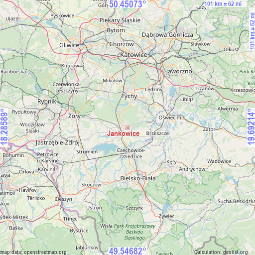
Jankowice GPS coordinates[2]
50° 0' 3.24" North, 18° 59' 20.436" East
| Map corner | latitude | longitude |
|---|---|---|
| Upper-left | 50.45073°, | 18.28589° |
| Center: | 50.0009°, | 18.98901° |
| Lower-right: | 49.54682°, | 19.69214° |
| Map W x H: | 100.5×100.5 km | = 62.4×62.4mi |
| max Lat: | 54.83135° ⇑82.4% North |
| Jankowice: | 50.0009° |
| min Lat: | ⇓17.6% South 49.21328° |
| min Long | Jankowice | max Long |
| 14.20249° | 18.98901° | 24.03723° |
| W 39.8%⇐ | ⇒60.2% E |
Elevation
Elevation of Jankowice is 247 m = 810 ft, and this is 55.6 m = 182 ft above average elevation for this country.
| Max E: |
974 m = 3196 ft | 24.9% |
| Jankowice | 247 m 810 ft | |
| Avg. | 191.4 m = 628 ft | |
Min E: |
-3 m = -10 ft | 75.1% |
See also: Poland elevation on elevation.city.
Geographical zone
Jankowice is located in North temperate zone (between Tropic of Cancer and the Arctic Circle). Distance of this North polar circle is 1841.6 km =1144.3 mi to North.| Distance of | km | miles | from Jankowice |
|---|---|---|---|
| North Pole | 4447.5 | 2763.5 | to North |
| Arctic Circle | 1841.6 | 1144.3 | to North |
| Tropic Cancer | 2953.7 | 1835.3 | to South |
| Equator | 5559.6 | 3454.6 | to South |


Nearby cities:
15 places around Jankowice: (largest is in red/bold)
• Bestwinka
9.4 km =5.8 mi,  143°
143°
• Bojszowy Nowe
7.2 km =4.5 mi,  37°
37°
• Czarków
6.2 km =3.9 mi,  288°
288°
• Frydek
6 km =3.7 mi,  94°
94°
• Gilowice
7.7 km =4.8 mi, 94°
• Goczałkowice Zdrój
6.4 km =4 mi,  192°
192°
• Góra
8.6 km =5.3 mi,  105°
105°
• Kaniów
7.8 km =4.8 mi,  145°
145°
• Kobiór
7.7 km =4.8 mi,  329°
329°
• Miedźna
4.8 km =3 mi,  115°
115°
• Międzyrzecze
6 km =3.7 mi,  64°
64°
• Piasek
3.1 km =1.9 mi, 290°
• Pszczyna
3.4 km =2.1 mi,  227°
227°
• Radostowice
7.7 km =4.8 mi,  271°
271°
• Wola
9.8 km =6.1 mi,  79°
79°
Sources, notices
• [Note1] Compared only with cities in Poland existing in our database
• [Src1] Map data: © OpenStreetMap contributors (CC-BY-SA)
• [Src2] Other city data from geonames.org with taken over terms of usage.
• [Src3] Geographical zone / Annual Mean Temperature by Robert A. Rohde @ Wikipedia
