Goczałkowice Zdrój geodata
Goczałkowice Zdrój (Silesia) is a seat of a third-order administrative division; located in Poland in Europe/Warsaw (GMT+2) time zone. With population of 6,321 people, there are 577 cities with bigger population in this country. Compared to other cities in Poland, 85.9% of cities are located further ↑North; 60.6% of cities are located further →East and 76% of cities have lower elevation than Goczałkowice Zdrój. Note1


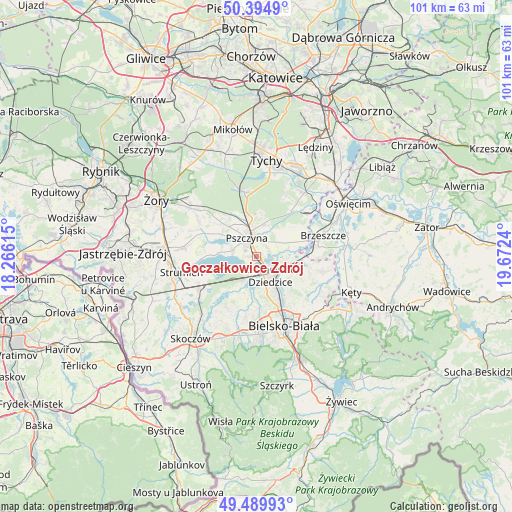
Goczałkowice Zdrój GPS coordinates[2]
49° 56' 40.344" North, 18° 58' 9.372" East
| Map corner | latitude | longitude |
|---|---|---|
| Upper-left | 50.3949°, | 18.26615° |
| Center: | 49.94454°, | 18.96927° |
| Lower-right: | 49.48993°, | 19.6724° |
| Map W x H: | 100.6×100.6 km | = 62.5×62.5mi |
| max Lat: | 54.83135° ⇑85.9% North |
| Goczałkowice Zdrój: | 49.94454° |
| min Lat: | ⇓14.1% South 49.21328° |
| min Long | Goczałkowice Z | max Long |
| 14.20249° | 18.96927° | 24.03723° |
| W 39.4%⇐ | ⇒60.6% E |
Elevation
Elevation of Goczałkowice Zdrój is 250 m = 820 ft, and this is 58.6 m = 192 ft above average elevation for this country.
| Max E: |
974 m = 3196 ft | 24% |
| Goczałkowice Zdrój | 250 m 820 ft | |
| Avg. | 191.4 m = 628 ft | |
Min E: |
-3 m = -10 ft | 76% |
See also: Poland elevation on elevation.city.
Geographical zone
Goczałkowice Zdrój is located in North temperate zone (between Tropic of Cancer and the Arctic Circle). Distance of this North polar circle is 1847.9 km =1148.2 mi to North.| Distance of | km | miles | from Goczałkowice Zdrój |
|---|---|---|---|
| North Pole | 4453.7 | 2767.4 | to North |
| Arctic Circle | 1847.9 | 1148.2 | to North |
| Tropic Cancer | 2947.4 | 1831.4 | to South |
| Equator | 5553.3 | 3450.7 | to South |


Nearby cities:
15 places around Goczałkowice Zdrój: (largest is in red/bold)
• Bestwina
8.2 km =5.1 mi,  129°
129°
• Bestwinka
7.1 km =4.4 mi,  100°
100°
• Bronów
8.2 km =5.1 mi,  204°
204°
• Czarków
9.3 km =5.8 mi,  331°
331°
• Czechowice-Dziedzice
4.3 km =2.7 mi,  143°
143°
• Frydek
9.4 km =5.8 mi,  52°
52°
• Jankowice
6.4 km =4 mi,  12°
12°
• Kaniów
5.8 km =3.6 mi,  91°
91°
• Ligota
5.3 km =3.3 mi,  194°
194°
• Mazańcowice
9.6 km =6 mi,  176°
176°
• Miedźna
7.1 km =4.4 mi, 53°
• Piasek
7.5 km =4.7 mi,  348°
348°
• Pszczyna
4.1 km =2.5 mi,  344°
344°
• Radostowice
9.1 km =5.7 mi,  315°
315°
• Zabrzeg
3.7 km =2.3 mi,  210°
210°
Sources, notices
• [Note1] Compared only with cities in Poland existing in our database
• [Src1] Map data: © OpenStreetMap contributors (CC-BY-SA)
• [Src2] Other city data from geonames.org with taken over terms of usage.
• [Src3] Geographical zone / Annual Mean Temperature by Robert A. Rohde @ Wikipedia
