Bronów geodata
Bronów (Silesia) is a populated place; located in Poland in Europe/Warsaw (GMT+2) time zone. With population of 1,012 people, there are 2445 cities with bigger population in this country. Compared to other cities in Poland, 88.6% of cities are located further ↑North; 61.5% of cities are located further →East and 78.1% of cities have lower elevation than Bronów. Note1


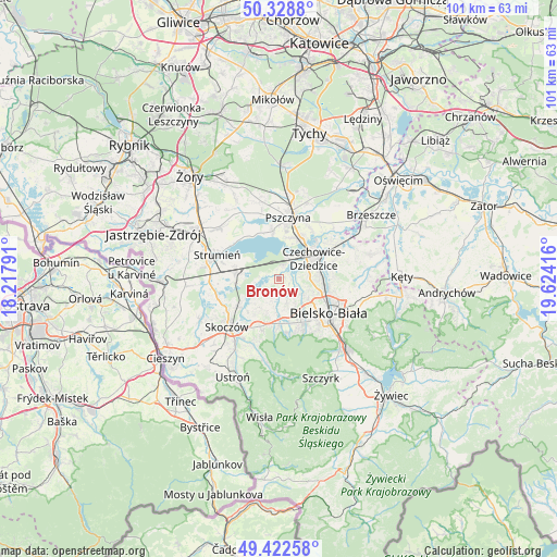
Bronów GPS coordinates[2]
49° 52' 40.152" North, 18° 55' 15.708" East
| Map corner | latitude | longitude |
|---|---|---|
| Upper-left | 50.3288°, | 18.21791° |
| Center: | 49.87782°, | 18.92103° |
| Lower-right: | 49.42258°, | 19.62416° |
| Map W x H: | 100.8×100.8 km | = 62.6×62.6mi |
| max Lat: | 54.83135° ⇑88.6% North |
| Bronów: | 49.87782° |
| min Lat: | ⇓11.4% South 49.21328° |
| min Long | Bronów | max Long |
| 14.20249° | 18.92103° | 24.03723° |
| W 38.5%⇐ | ⇒61.5% E |
Elevation
Elevation of Bronów is 258 m = 846 ft, and this is 66.6 m = 219 ft above average elevation for this country.
| Max E: |
974 m = 3196 ft | 21.9% |
| Bronów | 258 m 846 ft | |
| Avg. | 191.4 m = 628 ft | |
Min E: |
-3 m = -10 ft | 78.1% |
See also: Poland elevation on elevation.city.
Geographical zone
Bronów is located in North temperate zone (between Tropic of Cancer and the Arctic Circle). Distance of this North polar circle is 1855.3 km =1152.8 mi to North.| Distance of | km | miles | from Bronów |
|---|---|---|---|
| North Pole | 4461.2 | 2772.1 | to North |
| Arctic Circle | 1855.3 | 1152.8 | to North |
| Tropic Cancer | 2940 | 1826.8 | to South |
| Equator | 5545.9 | 3446.1 | to South |


Nearby cities:
15 places around Bronów: (largest is in red/bold)
• Bestwina
10 km =6.2 mi,  77°
77°
• Chybie
7.2 km =4.5 mi,  292°
292°
• Czechowice-Dziedzice
7.2 km =4.5 mi,  56°
56°
• Frelichów
8.6 km =5.3 mi, 294°
• Goczałkowice Zdrój
8.2 km =5.1 mi,  24°
24°
• Jasienica
7.2 km =4.5 mi,  179°
179°
• Jaworze
9.6 km =6 mi,  168°
168°
• Kowale
8.1 km =5 mi,  225°
225°
• Ligota
3.1 km =1.9 mi,  42°
42°
• Mazańcowice
4.6 km =2.9 mi,  118°
118°
• Mnich
8.3 km =5.2 mi,  279°
279°
• Pierściec
9.1 km =5.7 mi,  237°
237°
• Pogórze
10.3 km =6.4 mi,  212°
212°
• Zaborze
8.4 km =5.2 mi,  266°
266°
• Zabrzeg
4.5 km =2.8 mi, 20°
Sources, notices
• [Note1] Compared only with cities in Poland existing in our database
• [Src1] Map data: © OpenStreetMap contributors (CC-BY-SA)
• [Src2] Other city data from geonames.org with taken over terms of usage.
• [Src3] Geographical zone / Annual Mean Temperature by Robert A. Rohde @ Wikipedia
