Wysoka geodata
Wysoka (Lesser Poland) is a populated place; located in Poland in Europe/Warsaw (GMT+2) time zone. With population of 1,500 people, there are 1837 cities with bigger population in this country. Compared to other cities in Poland, 87.2% of cities are located further ↑North; 50.7% of cities are located further ←West and 90.6% of cities have lower elevation than Wysoka. Note1


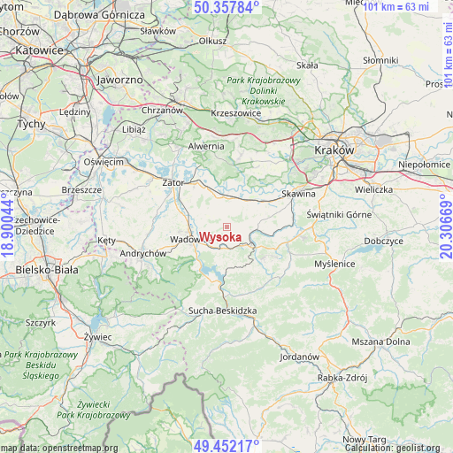
Wysoka GPS coordinates[2]
49° 54' 25.668" North, 19° 36' 12.816" East
| Map corner | latitude | longitude |
|---|---|---|
| Upper-left | 50.35784°, | 18.90044° |
| Center: | 49.90713°, | 19.60356° |
| Lower-right: | 49.45217°, | 20.30669° |
| Map W x H: | 100.7×100.7 km | = 62.6×62.6mi |
| max Lat: | 54.83135° ⇑87.2% North |
| Wysoka: | 49.90713° |
| min Lat: | ⇓12.8% South 49.21328° |
| min Long | Wysoka | max Long |
| 14.20249° | 19.60356° | 24.03723° |
| W 50.7%⇐ | ⇒49.3% E |
Elevation
Elevation of Wysoka is 338 m = 1109 ft, and this is 146.6 m = 481 ft above average elevation for this country.
| Max E: |
974 m = 3196 ft | 9.4% |
| Wysoka | 338 m 1109 ft | |
| Avg. | 191.4 m = 628 ft | |
Min E: |
-3 m = -10 ft | 90.6% |
See also: Poland elevation on elevation.city.
Geographical zone
Wysoka is located in North temperate zone (between Tropic of Cancer and the Arctic Circle). Distance of this North polar circle is 1852 km =1150.8 mi to North.| Distance of | km | miles | from Wysoka |
|---|---|---|---|
| North Pole | 4457.9 | 2770 | to North |
| Arctic Circle | 1852 | 1150.8 | to North |
| Tropic Cancer | 2943.2 | 1828.8 | to South |
| Equator | 5549.2 | 3448.1 | to South |


Nearby cities:
15 places around Wysoka: (largest is in red/bold)
• Barwałd Dolny
5.1 km =3.2 mi,  207°
207°
• Barwałd Górny
5.1 km =3.2 mi,  168°
168°
• Barwałd Średni
4.6 km =2.9 mi,  188°
188°
• Brzeźnica
6.5 km =4 mi,  10°
10°
• Bęczyn
5.1 km =3.2 mi,  52°
52°
• Kalwaria Zebrzydowska
6.9 km =4.3 mi,  129°
129°
• Klecza Dolna
5.4 km =3.4 mi,  240°
240°
• Klecza Górna
5.8 km =3.6 mi,  215°
215°
• Marcyporęba
4.3 km =2.7 mi, 9°
• Paszkówka
6.4 km =4 mi,  56°
56°
• Przytkowice
6 km =3.7 mi,  78°
78°
• Stanisław Dolny
3.6 km =2.2 mi,  94°
94°
• Stanisław Górny
1.9 km =1.2 mi, 75°
• Witanowice
5.7 km =3.5 mi,  282°
282°
• Zebrzydowice
5.3 km =3.3 mi,  110°
110°
Sources, notices
• [Note1] Compared only with cities in Poland existing in our database
• [Src1] Map data: © OpenStreetMap contributors (CC-BY-SA)
• [Src2] Other city data from geonames.org with taken over terms of usage.
• [Src3] Geographical zone / Annual Mean Temperature by Robert A. Rohde @ Wikipedia
